IMAGES TAKEN NEAR TO
KILLIN, FK21 8RA
Introduction
This page details the photographs taken nearby to FK21 8RA by members of the Geograph project.
The Geograph project started in 2005 with the aim of publishing, organising and preserving representative images for every square kilometre of Great Britain, Ireland and the Isle of Man.

There are currently over 7.5m images from over14,400 individuals and you can help contribute to the project by visiting https://www.geograph.org.uk
Image Map
Images are licensed for reuse under creativecommons.org/licenses/by-sa/2.0
Notes
- Clicking on the map will re-center to the selected point.
- The higher the marker number, the further away the image location is from the centre of the postcode.
Image Listing (6 Images Found)
Images are licensed for reuse under creativecommons.org/licenses/by-sa/2.0
Image
Details
Distance
1
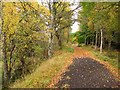
Killin Branch
A railway once linked Killin and Loch Tay with the Callander and Oban railway at Lix. Now a cycle path.
Image: © Richard Webb
Taken: 19 Oct 2010
0.10 miles
2
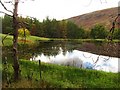
Curling pond, Acharn
Not the same pond as the one down by the road, this one is beside the former Killin Branch railway.
Image: © Richard Webb
Taken: 19 Oct 2010
0.12 miles
3
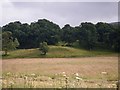
Field below the standing stone
This field is on the floodplain of the River Dochart. The standing stone is in the open canopy broadleaf woodland of the background.
Image: © C Michael Hogan
Taken: 27 Jul 2012
0.14 miles
4
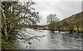
River Dochart, upstream
The river on a cloudy morning just outside Killin.
Image: © Trevor Littlewood
Taken: 11 Feb 2023
0.18 miles
6

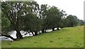
Grazing lands near Killin
In Stirlingshire
Image: © James Denham
Taken: 23 Jul 2013
0.24 miles