IMAGES TAKEN NEAR TO
Kennard Road, FALKIRK, FK2 0HH
Introduction
This page details the photographs taken nearby to Kennard Road, FK2 0HH by members of the Geograph project.
The Geograph project started in 2005 with the aim of publishing, organising and preserving representative images for every square kilometre of Great Britain, Ireland and the Isle of Man.

There are currently over 7.5m images from over14,400 individuals and you can help contribute to the project by visiting https://www.geograph.org.uk
Image Map
Images are licensed for reuse under creativecommons.org/licenses/by-sa/2.0
Notes
- Clicking on the map will re-center to the selected point.
- The higher the marker number, the further away the image location is from the centre of the postcode.
Image Listing (27 Images Found)
Images are licensed for reuse under creativecommons.org/licenses/by-sa/2.0
Image
Details
Distance
1
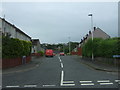
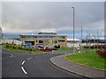
Kennard Road, Brightons
Looking south from Newlands Road.
Image: © JThomas
Taken: 21 Jun 2017
0.00 miles
3
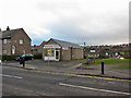
The Cabin, Newlands Road
The small premises sells hot and cold rolls - possibly popular with the pupils of Braes High School, which is located just along the road.
Image: © Richard Dorrell
Taken: 27 Jan 2015
0.09 miles
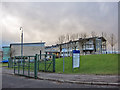
5
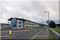
Her Majesty's Young Offenders Institution, Polmont
Viewed from its entrance in Blairlodge Avenue, Reddingmuirhead. This is the largest Young Offenders Institution in Scotland, designed to hold up to 830 inmates.
Image: © Richard Dorrell
Taken: 27 Jan 2015
0.12 miles
6
Braes High School
The school address is Newlands Road, Reddingmuirhead, but this entrance is from Wallace Brae Road. The comprehensive school has a roll of just under 1000 pupils, and opened in 2000.
Image: © Richard Dorrell
Taken: 27 Jan 2015
0.12 miles
7
Braes High School
Viewed from Wallace Brae Drive. The comprehensive school has a roll of just under 1000 pupils and opened in 2000.
Image: © Richard Dorrell
Taken: 27 Jan 2015
0.14 miles
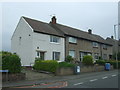
8
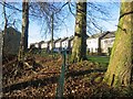
Polwarth Avenue.
The trees are survivors from the building, standing above the Polmont Burn.
Image: © Richard Webb
Taken: 12 Dec 2005
0.14 miles
9
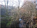
Polmont Burn
With new housing above, yet to make it on to the OS map.
Image: © Richard Webb
Taken: 12 Dec 2005
0.14 miles
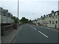
10
Newlands Road and Braes High School
The address of the school is Newlands Road, though the entrance to the school site is from Wallace Brae Drive - left at the roundabaout in the photograph.
Image: © Richard Dorrell
Taken: 27 Jan 2015
0.17 miles