IMAGES TAKEN NEAR TO
Canal Walk, FALKIRK, FK2 0FJ
Introduction
This page details the photographs taken nearby to Canal Walk, FK2 0FJ by members of the Geograph project.
The Geograph project started in 2005 with the aim of publishing, organising and preserving representative images for every square kilometre of Great Britain, Ireland and the Isle of Man.

There are currently over 7.5m images from over14,400 individuals and you can help contribute to the project by visiting https://www.geograph.org.uk
Image Map
Images are licensed for reuse under creativecommons.org/licenses/by-sa/2.0
Notes
- Clicking on the map will re-center to the selected point.
- The higher the marker number, the further away the image location is from the centre of the postcode.
Image Listing (30 Images Found)
Images are licensed for reuse under creativecommons.org/licenses/by-sa/2.0
Image
Details
Distance
1
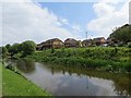
Canal Walk
New houses beside the Union Canal.
Image: © Richard Webb
Taken: 30 May 2014
0.02 miles
3
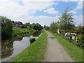
Union Canal
Opposite Polmont Junction in an area of recently built houses.
Image: © Richard Webb
Taken: 30 May 2014
0.04 miles
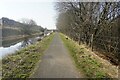
4

Union Canal at Redding
Following the towpath of the Union Canal westwards in Redding towards Bridge No. 55.
Image: © Chris Heaton
Taken: 9 Aug 2009
0.06 miles
5
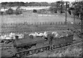
Ex-NBR 0-6-0 at Polmont
View northward: Edinburgh (left) - Glasgow (right) ex-NBR main line. Coming off Shed is one of the 168 NB Holmes class C (LNER J36) general purpose 0-6-0s, No. 65275, which was built as NB No. 180 in 1/1893, LNER No. 9180 (No. 5275 from 1946) and survived until 12/62. (It was not one of the 25 which served in France in World War One and acquired names).
Image: © Ben Brooksbank
Taken: 27 Sep 1957
0.06 miles
6
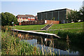
Canalside Building
This large grey building is the Grange Community Centre. See http://www.falkirk.gov.uk/services/education/community_learning/community_education_centres/grange.aspx
The sign is a warning that the jetty may be slippery when it is wet.
Image: © Anne Burgess
Taken: 26 Aug 2013
0.07 miles
7
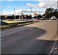
Redding Road at Blairlodge Avenue
Blairlodge Avenue gives access to the Scottish Prison Service College and HMP Polmont
Image: © Jim Smillie
Taken: 3 Nov 2021
0.08 miles
8
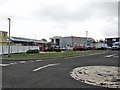
Scottish Prison Service College, Polmont
Located off Redding Road in Brightons. A new building is currently under construction, replacing the former gymnasium, and providing additional training and conference space. See also:Image
Image: © Richard Dorrell
Taken: 27 Jan 2015
0.08 miles
9
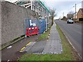
Temporary pavement
A temporary pathway has been laid over the grass verge at the side of Redding Road, Brightons, while construction of a new training and conference facility is underway for the Scottish Prison Service College. See also:Image
Image: © Richard Dorrell
Taken: 27 Jan 2015
0.09 miles
10
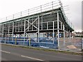
New building at SPS College, Polmont
The building under construction will provide additional training and conference space at the Scottish Prison Service College, off Redding Road. The building replaces the former gymnasium, which has been demolished.
Image: © Richard Dorrell
Taken: 27 Jan 2015
0.09 miles