IMAGES TAKEN NEAR TO
Shieldhill Road, FALKIRK, FK2 0DU
Introduction
This page details the photographs taken nearby to Shieldhill Road, FK2 0DU by members of the Geograph project.
The Geograph project started in 2005 with the aim of publishing, organising and preserving representative images for every square kilometre of Great Britain, Ireland and the Isle of Man.

There are currently over 7.5m images from over14,400 individuals and you can help contribute to the project by visiting https://www.geograph.org.uk
Image Map
Images are licensed for reuse under creativecommons.org/licenses/by-sa/2.0
Notes
- Clicking on the map will re-center to the selected point.
- The higher the marker number, the further away the image location is from the centre of the postcode.
Image Listing (11 Images Found)
Images are licensed for reuse under creativecommons.org/licenses/by-sa/2.0
Image
Details
Distance
3
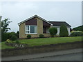
Bungalow on Shieldhill Road, Reddingmuirhead
Image: © JThomas
Taken: 21 Jun 2017
0.09 miles
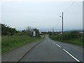
5
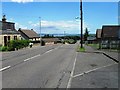
Entering Reddingmuirhead
Looking north east on the B810.
Image: © JThomas
Taken: 21 Jun 2017
0.10 miles
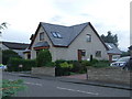
6
Shieldhill Road, Reddingmuirhead
Looking north east.
Image: © JThomas
Taken: 21 Jun 2017
0.12 miles
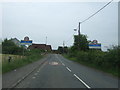
8
Shieldhill Road, Reddingrig Muir
Road dropping down towards Reddingmuirhead.
Image: © JThomas
Taken: 21 Jun 2017
0.21 miles
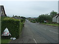
9
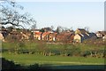
Reddingmuirhead.
Linear settlement following a ridge up from Polmont.
Image: © Richard Webb
Taken: 12 Dec 2005
0.21 miles
10

NEW
Temporary traffic light on the B810
At Reddingrig Muir and the entrance to Hillcrest Square.
Image: © M J Richardson
Taken: 12 Mar 2025
0.24 miles