IMAGES TAKEN NEAR TO
LOCHEARNHEAD, FK19 8NS
Introduction
This page details the photographs taken nearby to FK19 8NS by members of the Geograph project.
The Geograph project started in 2005 with the aim of publishing, organising and preserving representative images for every square kilometre of Great Britain, Ireland and the Isle of Man.

There are currently over 7.5m images from over14,400 individuals and you can help contribute to the project by visiting https://www.geograph.org.uk
Image Map
Images are licensed for reuse under creativecommons.org/licenses/by-sa/2.0
Notes
- Clicking on the map will re-center to the selected point.
- The higher the marker number, the further away the image location is from the centre of the postcode.
Image Listing (36 Images Found)
Images are licensed for reuse under creativecommons.org/licenses/by-sa/2.0
Image
Details
Distance
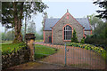
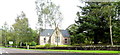
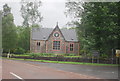
3
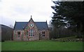
Church, Lochearnhead.
At the start of the South Loch Road, I think it is now disused, it has disappeared from the OS maps.
Image: © Richard Webb
Taken: 17 Jan 2006
0.07 miles
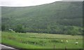
5
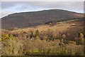
View from Craggan
Towards Ben Our, south of Lochearnhead.
Image: © Richard Webb
Taken: 27 Oct 2019
0.07 miles