IMAGES TAKEN NEAR TO
DOUNE, FK16 6HJ
Introduction
This page details the photographs taken nearby to FK16 6HJ by members of the Geograph project.
The Geograph project started in 2005 with the aim of publishing, organising and preserving representative images for every square kilometre of Great Britain, Ireland and the Isle of Man.

There are currently over 7.5m images from over14,400 individuals and you can help contribute to the project by visiting https://www.geograph.org.uk
Image Map
Images are licensed for reuse under creativecommons.org/licenses/by-sa/2.0
Notes
- Clicking on the map will re-center to the selected point.
- The higher the marker number, the further away the image location is from the centre of the postcode.
Image Listing (10 Images Found)
Images are licensed for reuse under creativecommons.org/licenses/by-sa/2.0
Image
Details
Distance
1
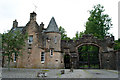
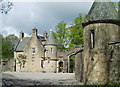
Entrance to Lanrick Castle
Entrance is all that remains from the 19th century castle, the former home of the Clan Gregor. The castle was destroyed in 2002.
Image: © Natasa
Taken: 2 Aug 2010
0.00 miles
2
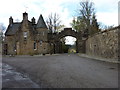
Golden Gates
The entrance to Lanrick Estate whose signboard gives the gates this name. The road seen through the archway leads down to the river Teith and then to Lanrick Castle.
Image: © James Allan
Taken: 18 Apr 2012
0.00 miles
3
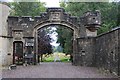
Golden Gates, Lanrick
An entrance to Lanrick (Castle), now derelict.
Image: © Alan Reid
Taken: 3 Sep 2019
0.01 miles
5
Lodge House and gateway, Lanrick
The impressive entrance to Lanrick Castle, one-time seat of the Clan McGregor. The castle, despite being a listed building, fell into disrepair and was controversially demolished by its owner in 2002.
Image: © Eileen Henderson
Taken: 21 May 2006
0.07 miles
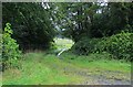
6
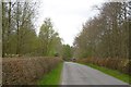
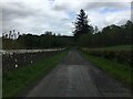
B8032 near Deanston
Passing through a small wood between Callander and Deanston.
Image: © Richard Webb
Taken: 28 Apr 2017
0.10 miles
7
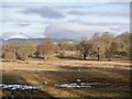
Parkland, Lanrick Castle
Lanrick Castle itself was demolished in 2002.
Image: © Richard Webb
Taken: 13 Jan 2023
0.17 miles
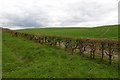
10
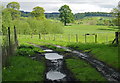
Muddy track
Taken near the River Teith north-west of Deanston village.
Image: © Eileen Henderson
Taken: 21 May 2006
0.25 miles