IMAGES TAKEN NEAR TO
DOUNE, FK16 6HF
Introduction
This page details the photographs taken nearby to FK16 6HF by members of the Geograph project.
The Geograph project started in 2005 with the aim of publishing, organising and preserving representative images for every square kilometre of Great Britain, Ireland and the Isle of Man.

There are currently over 7.5m images from over14,400 individuals and you can help contribute to the project by visiting https://www.geograph.org.uk
Image Map (Loading...)


Getting Data...Please wait
Leaflet Map data © OpenStreetMap
Images are licensed for reuse under creativecommons.org/licenses/by-sa/2.0
Notes
- Clicking on the map will re-center to the selected point.
- The higher the marker number, the further away the image location is from the centre of the postcode.
Image Listing (6 Images Found)
Images are licensed for reuse under creativecommons.org/licenses/by-sa/2.0
Image
Details
Distance
1
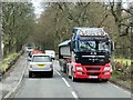
HGV on the A84 near Doune
Smith of Denny HGV (P90 YRS) on the A84, just to the north of Doune.
Image: © David Dixon
Taken: 28 Mar 2014
0.18 miles
2
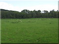
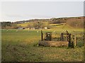
Grazing lands near Carse of Cambus
In Stirling District.
Image: © James Denham
Taken: 28 May 2011
0.19 miles
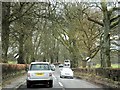
3

Old Milepost by the A84, Buchany, Kilmaddock parish
Stirling GM casting by the A84, in parish of Kilmaddock (Stirling District), Buchany, South of entrance to Antique Centre, East side of road. Not visible on Streetview after 2009.
Inscription reads:-
: DOUNE / 1 / MILE : : CALLANDER / 7 / MILES :
Surveyed
Milestone Society National ID: ST_STCA09
Image: © Milestone Society
Taken: Unknown
0.20 miles
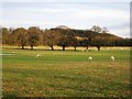
6
Carse of Cambus
Land grazed by sheep, there used to be a motor museum here.
Image: © Richard Webb
Taken: 2 Feb 2013
0.22 miles