IMAGES TAKEN NEAR TO
Buchany, DOUNE, FK16 6HD
Introduction
This page details the photographs taken nearby to FK16 6HD by members of the Geograph project.
The Geograph project started in 2005 with the aim of publishing, organising and preserving representative images for every square kilometre of Great Britain, Ireland and the Isle of Man.

There are currently over 7.5m images from over14,400 individuals and you can help contribute to the project by visiting https://www.geograph.org.uk
Image Map
Images are licensed for reuse under creativecommons.org/licenses/by-sa/2.0
Notes
- Clicking on the map will re-center to the selected point.
- The higher the marker number, the further away the image location is from the centre of the postcode.
Image Listing (7 Images Found)
Images are licensed for reuse under creativecommons.org/licenses/by-sa/2.0
Image
Details
Distance
2
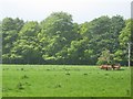
Cattle grazing near at Buchany in Stirlingshire
The grazing is especially rich after a spell of heavy rainfall.
Image: © James Denham
Taken: 28 May 2011
0.06 miles
4
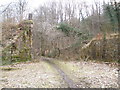
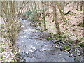
Remains of old railway bridge which crossed Annet Burn
Image: © John Ferguson
Taken: 16 Mar 2010
0.21 miles
5
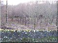
Young woodland, Burn of Cambus
A look over the wall to some trees probably planted around 1990 and yet to make it onto the 1:25000 map.
Image: © Richard Webb
Taken: 13 Jan 2009
0.22 miles