
IMAGES TAKEN NEAR TO
Argaty, DOUNE, FK16 6EN
Introduction
This page details the photographs taken nearby to FK16 6EN by members of the Geograph project.
The Geograph project started in 2005 with the aim of publishing, organising and preserving representative images for every square kilometre of Great Britain, Ireland and the Isle of Man.

There are currently over 7.5m images from over14,400 individuals and you can help contribute to the project by visiting https://www.geograph.org.uk
Image Map
Images are licensed for reuse under creativecommons.org/licenses/by-sa/2.0
Notes
- Clicking on the map will re-center to the selected point.
- The higher the marker number, the further away the image location is from the centre of the postcode.
Image Listing (6 Images Found)
Images are licensed for reuse under creativecommons.org/licenses/by-sa/2.0
Image
Details
Distance

2

Dunblane, Doune and Callander Railway
Looking westwards towards Doune. This later formed a route to Oban via Crianlarich. Now a cycle path.
Image: © Richard Webb
Taken: 28 Mar 2010
0.11 miles
3

Bridge over cycleway near Doune
Old railway line from Doune to Dunblane has recently been upgraded from muddy path to a tarmac cycleway.
Image: © Dave Coustick
Taken: 24 Jun 2006
0.13 miles
4

Ordnance Survey Cut Mark
The mark can be found on the parapet of the former railway bridge near to Easterton.
This benchmark has a recorded height of 63.578 metres above sea level.
For more detail see : https://www.bench-marks.org.uk/bm138396
Image: © Peter Wood
Taken: 19 Sep 2020
0.17 miles
5

Track that leads to Easterton
Looking northward. The bridge crosses a disused railway line that is now used as a recreational path and cycleway.
Image: © Peter Wood
Taken: 19 Sep 2020
0.18 miles
6
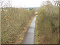
Dunblane, Doune and Callander Railway
Once a railway through to Oban, this is now a cycle path. The tarred section ends in the background, where the trackbed has been lost.
Image: © Richard Webb
Taken: 28 Mar 2010
0.22 miles