IMAGES TAKEN NEAR TO
North Lea, DOUNE, FK16 6DH
Introduction
This page details the photographs taken nearby to North Lea, FK16 6DH by members of the Geograph project.
The Geograph project started in 2005 with the aim of publishing, organising and preserving representative images for every square kilometre of Great Britain, Ireland and the Isle of Man.

There are currently over 7.5m images from over14,400 individuals and you can help contribute to the project by visiting https://www.geograph.org.uk
Image Map (Loading...)


Getting Data...Please wait
Leaflet Map data © OpenStreetMap
Images are licensed for reuse under creativecommons.org/licenses/by-sa/2.0
Notes
- Clicking on the map will re-center to the selected point.
- The higher the marker number, the further away the image location is from the centre of the postcode.
Image Listing (101 Images Found)
Images are licensed for reuse under creativecommons.org/licenses/by-sa/2.0
Image
Details
Distance
2
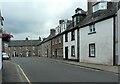
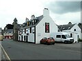
Houses on Balkerach Street, Doune
The nearest three properties date from about 1800 and are Category C listed http://portal.historicenvironment.scot/designation/LB24661.
Image: © Richard Sutcliffe
Taken: 9 Jul 2021
0.07 miles
3
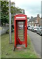
K6 telephone box
On Balkerach Street, Doune. There is no door or telephone apparatus and there are signs saying 'wet paint'. Presumably the box is about to be put to a new use.
Image: © Richard Sutcliffe
Taken: 9 Jul 2021
0.07 miles
4
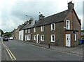
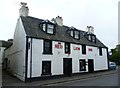
The Red Lion
Late 18th century public house on Balkerach Street, Doune. It is Category C listed http://portal.historicenvironment.scot/designation/LB24657.
Image: © Richard Sutcliffe
Taken: 9 Jul 2021
0.07 miles
5
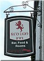
Sign for the Red Lion
Public house on Balkerach Street, Doune Image
Image: © Richard Sutcliffe
Taken: 9 Jul 2021
0.07 miles
6
Red Lion Inn, Doune
Proper local which also does good reasonable food. Had one good beer on.
Image: © Bill Boaden
Taken: 9 Aug 2013
0.08 miles
7
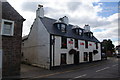
Red Lion Hotel
As far as I can make out, this lovely old inn has been misidentified on Google Streetview with a row of white cottages on the opposite side of the street.
Image: © kim traynor
Taken: 6 May 2012
0.08 miles
8
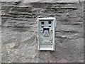
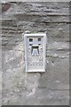
Ordnance Survey Flush Bracket S4950
This bracket can be found on the roadside wall of a building in Balkerach Street, Doune. The benchmark height is recorded as being 39.656 metres above sea level. For more detail see : http://www.bench-marks.org.uk/bm471
Image: © Peter Wood
Taken: 2 Oct 2017
0.08 miles
9
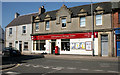
Doune Post Office and shop
Information & Heritage Centre on Balkerach Street.
Image: © Richard Sutcliffe
Taken: 24 May 2018
0.08 miles