IMAGES TAKEN NEAR TO
Bracklinn Place, FALKIRK, FK1 5US
Introduction
This page details the photographs taken nearby to Bracklinn Place, FK1 5US by members of the Geograph project.
The Geograph project started in 2005 with the aim of publishing, organising and preserving representative images for every square kilometre of Great Britain, Ireland and the Isle of Man.

There are currently over 7.5m images from over14,400 individuals and you can help contribute to the project by visiting https://www.geograph.org.uk
Image Map
Images are licensed for reuse under creativecommons.org/licenses/by-sa/2.0
Notes
- Clicking on the map will re-center to the selected point.
- The higher the marker number, the further away the image location is from the centre of the postcode.
Image Listing (6 Images Found)
Images are licensed for reuse under creativecommons.org/licenses/by-sa/2.0
Image
Details
Distance
1
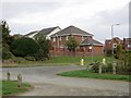
Lionthorn
Lionthorn Road from a car park serving the local woodland. This is a recent expansion of Falkirk.
Image: © Richard Webb
Taken: 23 Sep 2014
0.07 miles
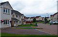
2
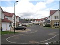
Glen Village
New housing development on the southern edge of Falkirk.
Image: © Richard Webb
Taken: 24 Aug 2009
0.07 miles
3
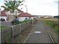
Footpath, Glen Village
Path out or Kilbean Wood through a new housing development.
Image: © Richard Webb
Taken: 24 Aug 2009
0.10 miles
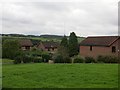
4
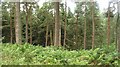
Kilbean Wood
Pine wood with a network of well surfaced paths.
Image: © Richard Webb
Taken: 24 Aug 2009
0.17 miles
5
Leny Cres, Glen Village, Falkirk
Housing area on the outskirts of Falkirk.
Image: © wfmillar
Taken: 23 Aug 2013
0.21 miles
6
Mitchell Place
New suburbs of Falkirk.
Image: © Richard Webb
Taken: 23 Sep 2014
0.24 miles