IMAGES TAKEN NEAR TO
Majors Loan, FALKIRK, FK1 5QF
Introduction
This page details the photographs taken nearby to Majors Loan, FK1 5QF by members of the Geograph project.
The Geograph project started in 2005 with the aim of publishing, organising and preserving representative images for every square kilometre of Great Britain, Ireland and the Isle of Man.

There are currently over 7.5m images from over14,400 individuals and you can help contribute to the project by visiting https://www.geograph.org.uk
Image Map
Images are licensed for reuse under creativecommons.org/licenses/by-sa/2.0
Notes
- Clicking on the map will re-center to the selected point.
- The higher the marker number, the further away the image location is from the centre of the postcode.
Image Listing (19 Images Found)
Images are licensed for reuse under creativecommons.org/licenses/by-sa/2.0
Image
Details
Distance
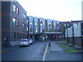
1
Original building Falkirk Royal Infirmary
This is the oldest part of the hospital. It is now used for administration. The building on the far left is the Diabetic Clinic.
Image: © Tom Sargent
Taken: 2 Oct 2008
0.14 miles
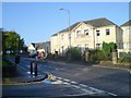
2
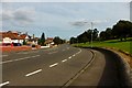
Drossie Road, Falkirk
Quiet suburban road leads down from the Falkirk High Station and the Union Canal towards the Infirmary.
Image: © Chris Heaton
Taken: 9 Aug 2009
0.14 miles
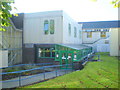
4
Windsor Unit Falkirk Royal Infirmary
This area deals with Maternity and Care of the Elderly
Image: © Tom Sargent
Taken: 2 Oct 2008
0.16 miles
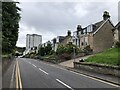
5
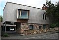
House in Drossie Road
This house is rather startling among the douce bungalows of Drossie Road, but is quite interesting when seen in isolation. Note the matching car port at the back and the clever use of the sloping site.
Image: © Anne Burgess
Taken: 5 Oct 2013
0.16 miles
6
Pharmacy Entrance Falkirk Royal Infirmary
Image: © Tom Sargent
Taken: 2 Oct 2008
0.17 miles
7
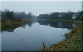
Union Canal, near Falkirk
This view is looking west, just beyond Falkirk Tunnel.
Image: © Stephen McKay
Taken: Unknown
0.17 miles
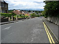
8
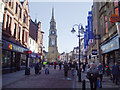
Falkirk High Street
Looking south east along this busy, popular High Street which is fully pedestrianised, There has been a Steeple here for four hundred years, the present one dates from 1814 and is a listed ancient monument.
Image: © Kevin Rae
Taken: 1 Mar 2006
0.17 miles
10
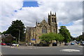
Erskine Community Halls, Falkirk
Former church built in 1905, in the 'Victorian Perpendicular Gothic' style. Named after The Reverend Ebeneezer Erskine of Stirling, who led a breakaway from the established Church of Scotland in 1733. Re-opened as a community centre in 2016. Facebook: https://en-gb.facebook.com/erskinecommunityhallsfalkirk/ .
Image: © Tim Heaton
Taken: 4 Jul 2018
0.21 miles