IMAGES TAKEN NEAR TO
Windsor Crescent, FALKIRK, FK1 5DD
Introduction
This page details the photographs taken nearby to Windsor Crescent, FK1 5DD by members of the Geograph project.
The Geograph project started in 2005 with the aim of publishing, organising and preserving representative images for every square kilometre of Great Britain, Ireland and the Isle of Man.

There are currently over 7.5m images from over14,400 individuals and you can help contribute to the project by visiting https://www.geograph.org.uk
Image Map
Images are licensed for reuse under creativecommons.org/licenses/by-sa/2.0
Notes
- Clicking on the map will re-center to the selected point.
- The higher the marker number, the further away the image location is from the centre of the postcode.
Image Listing (15 Images Found)
Images are licensed for reuse under creativecommons.org/licenses/by-sa/2.0
Image
Details
Distance
1
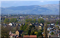
Falkirk and the Ochil Hills
Looking over the Bantaskin area of Falkirk from a Glasgow bound train from Edinburgh. The wind turbines are around 7Km away, beyond the M9 motorway at Rosehill, near Letham Moss Image
Image: © Thomas Nugent
Taken: 30 Apr 2018
0.14 miles
2
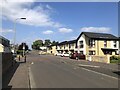
Houses, Blinkbonny Road
Built on the site of Falkirk High School's previous building. The school is now in a newer building nearby.
Image: © Richard Webb
Taken: 30 Aug 2024
0.16 miles
3
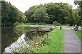
Canal Junction
This was the point where boats travelling to the Forth and Clyde Canal originally left the Union Canal, bearing right to descend a series of eleven locks, basins and docks to Camelon, passing a chemical works, two foundries and an alum works on the way. The locks, basins and docks, and the industries, have all vanished, replaced by housing estates for the most part. A path follows the former towpath part of the way down the brae. The canal continues for a short distance to the left. For the reciprocal view see Image
Image: © Anne Burgess
Taken: 5 Oct 2013
0.18 miles
4
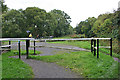
Canal Gates
This is the reciprocal view of Image I wasn't quite quick enough to catch the cyclists negotiating the chicane round the end of the gate here.
Image: © Anne Burgess
Taken: 5 Oct 2013
0.18 miles
5
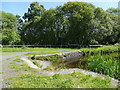
Slipway on the Union Canal
The widening of the canal at this slipway is all that remains of the top of the flights of locks and basins that once joined this canal to the Forth and Clyde Canal in the valley below. Derelict for many decades, the link was eventually restored further west with the construction of the Falkirk Wheel. See also Image The line of the towpath alongside the long-gone locks is now a cycle rouet, a sign for which can be seen here.
Image: © Stephen Craven
Taken: 27 Jun 2019
0.18 miles
6
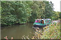
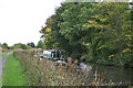
Narrowboat at Bantaskine
Just about every crew who passed me made a comment along the lines of 'this is the way to travel!' and this crew, aboard 'Peccadillo', was no exception. The wooded far bank is part of South Bantaskine Estate, a popular public park.
Image: © Anne Burgess
Taken: 5 Oct 2013
0.18 miles
7
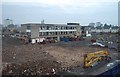
The Old Falkirk High School
Image taken from the new Falkirk High School towards the old school which is clearly being demolished.
Image: © John Chroston
Taken: 30 Oct 2009
0.19 miles
8
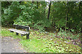
Surrounded by Litter
Benches are not plentiful along this end of the canal, and when you see the mess round this one, perhaps that's no bad thing. The edge of the wood is full of discarded bottles and other rubbish; in fact this image doesn't really show the sheer quantity of it.
Image: © Anne Burgess
Taken: 5 Oct 2013
0.20 miles
9
Heading East
The narrowboat 'Peccadillo' is making her way east towards Falkirk and ultimately perhaps Edinburgh.
Image: © Anne Burgess
Taken: 5 Oct 2013
0.20 miles
10
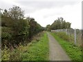
Union Canal, Bantaskin
The fence is beside the main railway between Glasgow and Edinburgh.
Image: © Richard Webb
Taken: 23 Sep 2014
0.20 miles