IMAGES TAKEN NEAR TO
Braco, DUNBLANE, FK15 9RB
Introduction
This page details the photographs taken nearby to FK15 9RB by members of the Geograph project.
The Geograph project started in 2005 with the aim of publishing, organising and preserving representative images for every square kilometre of Great Britain, Ireland and the Isle of Man.

There are currently over 7.5m images from over14,400 individuals and you can help contribute to the project by visiting https://www.geograph.org.uk
Image Map
Images are licensed for reuse under creativecommons.org/licenses/by-sa/2.0
Notes
- Clicking on the map will re-center to the selected point.
- The higher the marker number, the further away the image location is from the centre of the postcode.
Image Listing (6 Images Found)
Images are licensed for reuse under creativecommons.org/licenses/by-sa/2.0
Image
Details
Distance
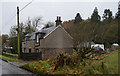
2
Wester Feddal
On the road to Braco [B8033].
Image: © M J Richardson
Taken: 5 Sep 2010
0.08 miles
3
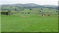
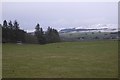
Grassland, Feddal
Grazing land with a view towards the Ochil Hills.
Image: © Richard Webb
Taken: 3 Jun 2010
0.14 miles
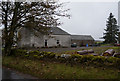
4
Field, Wester Feddal
Lots of kinky contours here due to glacial deposition.
Image: © Richard Webb
Taken: 22 Mar 2017
0.17 miles
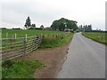
5
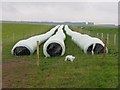
Farm produce at Wester Feddal
Not strictly bales, and I suppose they contain silage in the making, but I'm not sure how these are formed - sausage machine?
Image: © M J Richardson
Taken: 5 Sep 2010
0.21 miles