IMAGES TAKEN NEAR TO
Muthill Road, DUNBLANE, FK15 9LQ
Introduction
This page details the photographs taken nearby to Muthill Road, FK15 9LQ by members of the Geograph project.
The Geograph project started in 2005 with the aim of publishing, organising and preserving representative images for every square kilometre of Great Britain, Ireland and the Isle of Man.

There are currently over 7.5m images from over14,400 individuals and you can help contribute to the project by visiting https://www.geograph.org.uk
Image Map
Images are licensed for reuse under creativecommons.org/licenses/by-sa/2.0
Notes
- Clicking on the map will re-center to the selected point.
- The higher the marker number, the further away the image location is from the centre of the postcode.
Image Listing (5 Images Found)
Images are licensed for reuse under creativecommons.org/licenses/by-sa/2.0
Image
Details
Distance
1
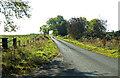
On the Old Military Road
Towards Braco
Image: © Anthony O'Neil
Taken: 17 Oct 2015
0.14 miles
2
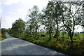
Old Military Road
Recently resurfaced.
Image: © Richard Webb
Taken: 25 May 2017
0.14 miles
3
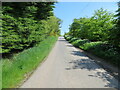
Minor road near to Spring Bank
Looking north-eastward along the line of an Old Military Road.
Image: © Peter Wood
Taken: 29 May 2021
0.22 miles
4
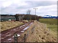
Garrick Farm near Braco
Looking east along the farm road with snowcoverd Ochils in the distance
Image: © Robert Bone
Taken: 19 Mar 2006
0.24 miles
5
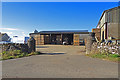
Farm buildings at Springbank
Near Braco
Image: © Anthony O'Neil
Taken: 17 Oct 2015
0.25 miles