IMAGES TAKEN NEAR TO
Braco, DUNBLANE, FK15 9LJ
Introduction
This page details the photographs taken nearby to FK15 9LJ by members of the Geograph project.
The Geograph project started in 2005 with the aim of publishing, organising and preserving representative images for every square kilometre of Great Britain, Ireland and the Isle of Man.

There are currently over 7.5m images from over14,400 individuals and you can help contribute to the project by visiting https://www.geograph.org.uk
Image Map
Images are licensed for reuse under creativecommons.org/licenses/by-sa/2.0
Notes
- Clicking on the map will re-center to the selected point.
- The higher the marker number, the further away the image location is from the centre of the postcode.
Image Listing (7 Images Found)
Images are licensed for reuse under creativecommons.org/licenses/by-sa/2.0
Image
Details
Distance
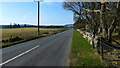
1
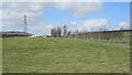
Ewes and lambs near Gunnocks
Still a cold wind, but some sun too for the lambs.
Image: © Richard Webb
Taken: 24 Apr 2013
0.19 miles
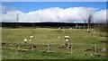
5
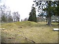
Rapha Centre's woodland
Some recently planted woodlands behind the sheep. There has been quite a bit of planting on the slopes north of Braco by the Rapha Centre which is situated on the road to Comrie.
Image: © Richard Webb
Taken: 24 Apr 2013
0.22 miles
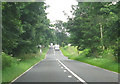
6
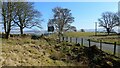
The junction of the B827 and the A822
Just by the Black Hill Roman Camp.
Image: © Gordon Brown
Taken: 27 Mar 2022
0.23 miles