IMAGES TAKEN NEAR TO
Roman Way, DUNBLANE, FK15 9DQ
Introduction
This page details the photographs taken nearby to Roman Way, FK15 9DQ by members of the Geograph project.
The Geograph project started in 2005 with the aim of publishing, organising and preserving representative images for every square kilometre of Great Britain, Ireland and the Isle of Man.

There are currently over 7.5m images from over14,400 individuals and you can help contribute to the project by visiting https://www.geograph.org.uk
Image Map
Images are licensed for reuse under creativecommons.org/licenses/by-sa/2.0
Notes
- Clicking on the map will re-center to the selected point.
- The higher the marker number, the further away the image location is from the centre of the postcode.
Image Listing (15 Images Found)
Images are licensed for reuse under creativecommons.org/licenses/by-sa/2.0
Image
Details
Distance
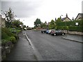
1
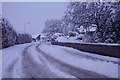
Roman Way, Dunblane
Like most side roads, a pig to use in snow.
Image: © Richard Webb
Taken: 17 Jan 2018
0.07 miles
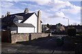
2
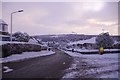
Old Doune Road
Junction with Roman Way
Image: © Richard Webb
Taken: 17 Jan 2018
0.09 miles
3
Old Doune Road, Dunblane
Junction with Wallace Road.
Image: © Richard Webb
Taken: 24 May 2019
0.14 miles
4
Covered reservoir, Dunblane
Hill top to the west of the town centre in an area of infill housing inside the bypass. The reservoir must be disused as there is no fencing.
Image: © Richard Webb
Taken: 16 Dec 2016
0.17 miles
5
Keir Street, Dunblane
Junction with Old Doune Road. While many houses in the area are relatively modern, there are some older stone built houses along Keir Street.
Image: © Richard Webb
Taken: 13 Feb 2018
0.18 miles
6
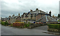
Cawdor Crescent
Traditional stone-built houses in Dunblane, viewed on a disappointingly dull November day.
Image: © Mary and Angus Hogg
Taken: 12 Nov 2014
0.18 miles
7
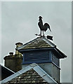
A Weather Vane in Cawdor Crescent
Located on one of the traditional buildings in Dunblane's Cawdor Crescent.
Image: © Mary and Angus Hogg
Taken: 12 Nov 2014
0.18 miles
8
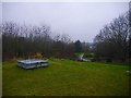
Covered reservoir, Dunblane
Unfortified, therefore almost certainly redundant, it occupies a hill top which was also once occupied by a Roman camp. Now this is an informal green space amongst modern housing.
Image: © Richard Webb
Taken: 16 Dec 2016
0.19 miles
9
Old Doune Road
Residential street. You can still get to Doune this way, but only by non motorised transport, the route is partly a path once out of Dunblane.
Image: © Richard Webb
Taken: 3 Sep 2008
0.23 miles
10
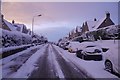
Old Doune Road
Can be a bit of a .... to get up in snowy conditions.
Image: © Richard Webb
Taken: 17 Jan 2018
0.24 miles