IMAGES TAKEN NEAR TO
Doune Road, DUNBLANE, FK15 9AT
Introduction
This page details the photographs taken nearby to Doune Road, FK15 9AT by members of the Geograph project.
The Geograph project started in 2005 with the aim of publishing, organising and preserving representative images for every square kilometre of Great Britain, Ireland and the Isle of Man.

There are currently over 7.5m images from over14,400 individuals and you can help contribute to the project by visiting https://www.geograph.org.uk
Image Map
Images are licensed for reuse under creativecommons.org/licenses/by-sa/2.0
Notes
- Clicking on the map will re-center to the selected point.
- The higher the marker number, the further away the image location is from the centre of the postcode.
Image Listing (83 Images Found)
Images are licensed for reuse under creativecommons.org/licenses/by-sa/2.0
Image
Details
Distance
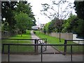
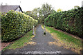
2
Kilbryde Crescent, Dunblane
Looking north-eastward.
Image: © Peter Wood
Taken: 19 Sep 2020
0.09 miles
3
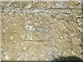
Ordnance Survey Cut Mark
The mark can be found on a roadside wall in Doune Road (A820), Dunblane.
This benchmark has a recorded height of 74.991 metres above sea level.
For more detail see : https://www.bench-marks.org.uk/bm114620
Image: © Peter Wood
Taken: 19 Sep 2020
0.10 miles
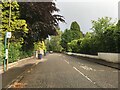
5
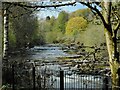
Allan Water
A zoomed view upstream from beside the Faery Bridge.
Image: © Richard Sutcliffe
Taken: 29 Apr 2022
0.11 miles
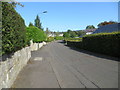
6
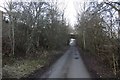
Dunblane, Doune and Callander Railway track bed
The line was closed in 1966.
Image: © Richard Webb
Taken: 26 Jan 2017
0.12 miles
7
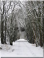
Dunblane in Winter. Railway ghosts.
Long-gone (1966) Dunblane to Callander railway now used as a drive into a house. The old bridge still remains and is now a footpath down to the river.
Image: © Robert Smallman
Taken: 25 Feb 2010
0.12 miles
8
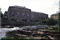
The former Springbank Mills, Dunblane
A rather flat and against the light shot of a building that has been converted to within an inch of its life. The archway on the right may have been the tail race from the water turbine. I had completely forgotten taking these pictures and they form a sad contrast to the earlier monochrome images.
Image: © Chris Allen
Taken: 29 May 1989
0.12 miles
9
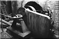
Springbank Mills, Dunblane - water turbine
This derelict textile mill still contained a Robey steam engine and two water turbines. This is one of the turbines. The runner is through the wall and submerged. On this side of the wall are the drive pulley and the governor. The mill was later converted to accommodation and lost most of its character. The steam engine was scrapped but it is possible parts of the turbines may still survive. Given the current interest in microhydropower it is even possible the site still generates (possibly with new turbines).
Image: © Chris Allen
Taken: 21 Jul 1983
0.13 miles