IMAGES TAKEN NEAR TO
Doune Road, DUNBLANE, FK15 9AR
Introduction
This page details the photographs taken nearby to Doune Road, FK15 9AR by members of the Geograph project.
The Geograph project started in 2005 with the aim of publishing, organising and preserving representative images for every square kilometre of Great Britain, Ireland and the Isle of Man.

There are currently over 7.5m images from over14,400 individuals and you can help contribute to the project by visiting https://www.geograph.org.uk
Image Map
Images are licensed for reuse under creativecommons.org/licenses/by-sa/2.0
Notes
- Clicking on the map will re-center to the selected point.
- The higher the marker number, the further away the image location is from the centre of the postcode.
Image Listing (538 Images Found)
Images are licensed for reuse under creativecommons.org/licenses/by-sa/2.0
Image
Details
Distance
1
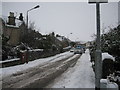
Dunblane in Winter. Kilbryde Crescent looking northeast
Image: © Robert Smallman
Taken: 25 Feb 2010
0.04 miles
2

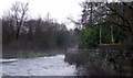
Footpath, The Haugh
The embankment on the left is for the railway.
Image: © Richard Sutcliffe
Taken: 29 Apr 2022
0.07 miles
4

Dunblane Junction
Up to 1966 a line departed here for Callander and Oban. The Stirling to Perth railway is still open.
Image: © Richard Webb
Taken: 26 Jan 2017
0.08 miles
5
Allan Water
A patch of mist on the bend in the river below the cathedral.
Image: © Thomas Nugent
Taken: 2 Jan 2013
0.09 miles
6
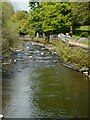
Allan Water
Looking upstream. The Dunblane Riverside Path follows the east bank of the river.
Image: © Richard Sutcliffe
Taken: 29 Apr 2022
0.09 miles
7
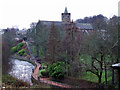
Dunblane Cathedral
Viewed from the footbridge between Bridgend and Caledonian Place.
Image: © Thomas Nugent
Taken: 2 Jan 2013
0.09 miles
8
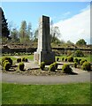
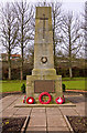
War memorial, Dunblane
The war memorial was originally located opposite St Mary's Church at the junction of Perth Road and Glen Road. It was unveiled in October 1921. It was moved to its present location to allow for road improvements. The memorial was dismantled, cleaned and re-assembled in 1959. It was restored again in 2010. It is Category C listed http://portal.historicenvironment.scot/designation/LB48950.
Image: © Richard Sutcliffe
Taken: 29 Apr 2022
0.09 miles
9
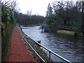
Footpath at Allan Water
The railway line is on the left.
Image: © Thomas Nugent
Taken: 2 Jan 2013
0.09 miles
10

War Memorial in Dunblane
Dunblane Cathedral has a commanding presence over the lower ground on this side of the river.
Image: © Doug Lee
Taken: 3 Aug 2014
0.10 miles