IMAGES TAKEN NEAR TO
Ochiltree, DUNBLANE, FK15 0PA
Introduction
This page details the photographs taken nearby to Ochiltree, FK15 0PA by members of the Geograph project.
The Geograph project started in 2005 with the aim of publishing, organising and preserving representative images for every square kilometre of Great Britain, Ireland and the Isle of Man.

There are currently over 7.5m images from over14,400 individuals and you can help contribute to the project by visiting https://www.geograph.org.uk
Image Map
Images are licensed for reuse under creativecommons.org/licenses/by-sa/2.0
Notes
- Clicking on the map will re-center to the selected point.
- The higher the marker number, the further away the image location is from the centre of the postcode.
Image Listing (10 Images Found)
Images are licensed for reuse under creativecommons.org/licenses/by-sa/2.0
Image
Details
Distance
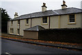
1
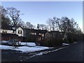
Ochiltree, Dunblane
A residential street with big houses in Dunblane. It has easy access to the surrounding woodland. The sun had just set.
Image: © Richard Webb
Taken: 30 Jan 2019
0.06 miles
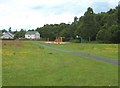
2
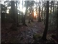
Kippendavie Wood
One of the woods within Dunblane.
Image: © Richard Webb
Taken: 30 Jan 2019
0.11 miles
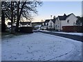
3
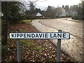
Kippendavie Road, Dunblane
14 years after Image
Image: © Richard Webb
Taken: 12 Nov 2020
0.19 miles
4
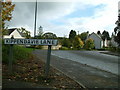
New houses up from Kippendavie lane, by Kippendavie Wood
Image: © Simon McKeating
Taken: 20 Oct 2006
0.20 miles
8
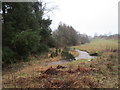
Scouring Burn, Dunblane
Carrying much more water than usual.
Image: © Jonathan Thacker
Taken: 21 Feb 2020
0.22 miles
9
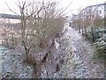
Kellie Wynd
A ditch runs into the Ryland Burn beside Kellie Wynd on the edge of Dunblane
Image: © Richard Webb
Taken: 30 Nov 2012
0.24 miles
10
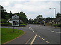
Perth Road, Dunblane
The Perth Road in Dunblane looking towards the city centre. Queen Victoria School is on the left.
Image: © Dean Molyneaux
Taken: 1 Jul 2009
0.24 miles