IMAGES TAKEN NEAR TO
Kinbuck, DUNBLANE, FK15 0NW
Introduction
This page details the photographs taken nearby to FK15 0NW by members of the Geograph project.
The Geograph project started in 2005 with the aim of publishing, organising and preserving representative images for every square kilometre of Great Britain, Ireland and the Isle of Man.

There are currently over 7.5m images from over14,400 individuals and you can help contribute to the project by visiting https://www.geograph.org.uk
Image Map
Images are licensed for reuse under creativecommons.org/licenses/by-sa/2.0
Notes
- Clicking on the map will re-center to the selected point.
- The higher the marker number, the further away the image location is from the centre of the postcode.
Image Listing (10 Images Found)
Images are licensed for reuse under creativecommons.org/licenses/by-sa/2.0
Image
Details
Distance
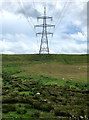
2
View from a Stirling-Perth train - power lines near Kinbuck
Image: © Nigel Thompson
Taken: 11 May 2016
0.18 miles
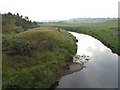
6
Towards Kinbuck 's bridge over Allan Water
Looking over railway line in north west[ish] direction, from near Knaggyfauld.
Image: © Derek Ferris
Taken: 12 Jul 2007
0.21 miles
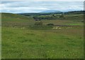
8
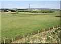
Strathallan
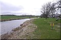
Looking up the Allan Water from the bridge on the B8033 north of Kinbuck.
Image: © M J Richardson
Taken: 5 Sep 2010
0.23 miles
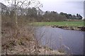
9
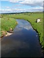
Allan Water
Taken from the bridge North of Kinbuck
Image: © Dominic Dawn Harry and Jacob Paterson
Taken: 3 Jun 2006
0.24 miles
10
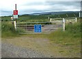
Level Crossing near Knaggyfauld
Must be there for farming reasons.
Image: © Derek Ferris
Taken: 12 Jul 2007
0.25 miles