IMAGES TAKEN NEAR TO
Kinbuck, DUNBLANE, FK15 0NL
Introduction
This page details the photographs taken nearby to FK15 0NL by members of the Geograph project.
The Geograph project started in 2005 with the aim of publishing, organising and preserving representative images for every square kilometre of Great Britain, Ireland and the Isle of Man.

There are currently over 7.5m images from over14,400 individuals and you can help contribute to the project by visiting https://www.geograph.org.uk
Image Map
Images are licensed for reuse under creativecommons.org/licenses/by-sa/2.0
Notes
- Clicking on the map will re-center to the selected point.
- The higher the marker number, the further away the image location is from the centre of the postcode.
Image Listing (8 Images Found)
Images are licensed for reuse under creativecommons.org/licenses/by-sa/2.0
Image
Details
Distance
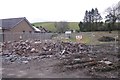
4
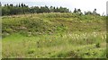
Former sand pit, Kinbuck
Glacially deposited sands were quarried here. Now the digging is done by the large rabbit population. Near the Stirling to Perth railway.
Image: © Richard Webb
Taken: 3 Sep 2008
0.14 miles
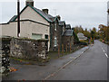
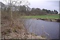
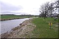
6
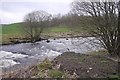
Allan Water, Kinbuck
Beside the Kinbuck Mill.
Image: © Richard Webb
Taken: 22 Mar 2017
0.23 miles
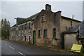
7
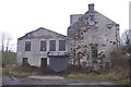
Ferranti Mill, Kinbuck
Derelict building beside the Allan Water - any relation to the electronics Ferranti as in Ferranti Thistle FC?
Image: © Richard Webb
Taken: 22 Mar 2017
0.24 miles