IMAGES TAKEN NEAR TO
Braco, DUNBLANE, FK15 0NA
Introduction
This page details the photographs taken nearby to FK15 0NA by members of the Geograph project.
The Geograph project started in 2005 with the aim of publishing, organising and preserving representative images for every square kilometre of Great Britain, Ireland and the Isle of Man.

There are currently over 7.5m images from over14,400 individuals and you can help contribute to the project by visiting https://www.geograph.org.uk
Image Map
Images are licensed for reuse under creativecommons.org/licenses/by-sa/2.0
Notes
- Clicking on the map will re-center to the selected point.
- The higher the marker number, the further away the image location is from the centre of the postcode.
Image Listing (12 Images Found)
Images are licensed for reuse under creativecommons.org/licenses/by-sa/2.0
Image
Details
Distance
1
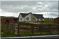
Perth and Kinross : Kinburn
A house with some sheep in the garden.
Image: © Lewis Clarke
Taken: 25 Apr 2016
0.01 miles
3
Kinburn
Taken from opposite side of dual carriageway. Looking south east up the hillside, towards the radio mast.
Image: © Derek Ferris
Taken: 12 Jul 2007
0.03 miles
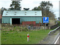
4
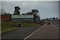
Perth and Kinross : The A9
Some barns and a layby beside the A9.
Image: © Lewis Clarke
Taken: 25 Apr 2016
0.07 miles
5
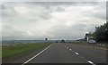
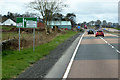
Approaching road junction at Kinburn
A9 north
Image: © John Firth
Taken: 26 Jul 2012
0.08 miles
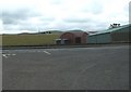
6
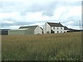
Mid Rottearns Farm
Farmhouse and other buildings, looking north east[ish]
Image: © Derek Ferris
Taken: 12 Jul 2007
0.12 miles
8
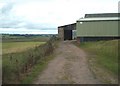
Looking North East from Mid Rottearns
Looking along farm track to main barn.
Image: © Derek Ferris
Taken: 12 Jul 2007
0.13 miles
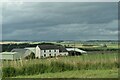
9
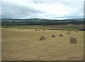
North from Mid Rottearns
It's been a busy week for the farmer.
Image: © Derek Ferris
Taken: 12 Jul 2007
0.18 miles