IMAGES TAKEN NEAR TO
Greenloaning, DUNBLANE, FK15 0LX
Introduction
This page details the photographs taken nearby to FK15 0LX by members of the Geograph project.
The Geograph project started in 2005 with the aim of publishing, organising and preserving representative images for every square kilometre of Great Britain, Ireland and the Isle of Man.

There are currently over 7.5m images from over14,400 individuals and you can help contribute to the project by visiting https://www.geograph.org.uk
Image Map
Images are licensed for reuse under creativecommons.org/licenses/by-sa/2.0
Notes
- Clicking on the map will re-center to the selected point.
- The higher the marker number, the further away the image location is from the centre of the postcode.
Image Listing (10 Images Found)
Images are licensed for reuse under creativecommons.org/licenses/by-sa/2.0
Image
Details
Distance
2

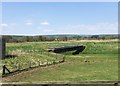
Flooded ground, Greenloaning
Nearby, the Allan Water has been canalised with high embankments to prevent flooding. This appears to be a carr with more surface water after a period of heavy rainfall.
Image: © Richard Webb
Taken: 30 Nov 2012
0.08 miles
3

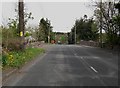
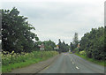
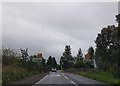
A822, Greenloaning
The road to Crieff from the nearby A9.
Image: © Richard Webb
Taken: 19 Jan 2017
0.10 miles
4
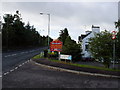
Allanbank Inn, Greenloaning
Taken at the junction with a road leading to a modern housing development
Image: © Calum McRoberts
Taken: 8 Sep 2005
0.11 miles
6
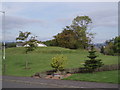
Site of Roman signal station, Greenloaning
Image: © Eric McGill
Taken: 30 Sep 2007
0.11 miles
8
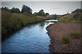
River Knaik at Greenloaning
The Knaik joins the Allan Water at the bridge, which carries the A822.
Image: © Alan Reid
Taken: 24 Aug 2018
0.14 miles
9
View from a Stirling-Perth train - Bridge over Allan Water
Image: © Nigel Thompson
Taken: 11 May 2016
0.18 miles
10
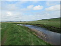
Floodplain by the River Knaik
Close to the confluence between the Knaik and the Allan Water.
Image: © Alan O'Dowd
Taken: 7 May 2022
0.24 miles