IMAGES TAKEN NEAR TO
Sheriffmuir, DUNBLANE, FK15 0LP
Introduction
This page details the photographs taken nearby to FK15 0LP by members of the Geograph project.
The Geograph project started in 2005 with the aim of publishing, organising and preserving representative images for every square kilometre of Great Britain, Ireland and the Isle of Man.

There are currently over 7.5m images from over14,400 individuals and you can help contribute to the project by visiting https://www.geograph.org.uk
Image Map
Images are licensed for reuse under creativecommons.org/licenses/by-sa/2.0
Notes
- Clicking on the map will re-center to the selected point.
- The higher the marker number, the further away the image location is from the centre of the postcode.
Image Listing (9 Images Found)
Images are licensed for reuse under creativecommons.org/licenses/by-sa/2.0
Image
Details
Distance
1
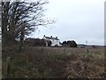
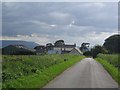
Farmhouse, Stonehill
Now unoccupied and advertised for sale and redevelopment.
Image: © Alpin Stewart
Taken: 1 Jan 2014
0.01 miles
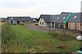
3
Stonehill
No longer a farm. Taken 14 years after Image
Image: © Richard Webb
Taken: 4 Nov 2020
0.03 miles
5
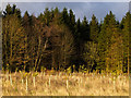
Tree planting at Stonehill
Newly planted trees in front of established woodland near Stonehill.
Image: © William Starkey
Taken: 27 Oct 2011
0.11 miles
6
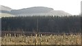
New woodland, Stonehill
More shelter for the arable land on the lower slopes of the Ochil Hills.
Image: © Richard Webb
Taken: 7 Feb 2012
0.15 miles

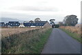
8
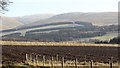
Stonehill farmland
Arable land on the way up to Sheriff Muir with a view up to Meikle Corum in the Ochil Hills.
The shelter belts around Cauldhame stand out beneath the rough grazing on the hill.
Image: © Richard Webb
Taken: 7 Feb 2012
0.17 miles