IMAGES TAKEN NEAR TO
Glassingall, DUNBLANE, FK15 0GX
Introduction
This page details the photographs taken nearby to FK15 0GX by members of the Geograph project.
The Geograph project started in 2005 with the aim of publishing, organising and preserving representative images for every square kilometre of Great Britain, Ireland and the Isle of Man.

There are currently over 7.5m images from over14,400 individuals and you can help contribute to the project by visiting https://www.geograph.org.uk
Image Map
Images are licensed for reuse under creativecommons.org/licenses/by-sa/2.0
Notes
- Clicking on the map will re-center to the selected point.
- The higher the marker number, the further away the image location is from the centre of the postcode.
Image Listing (5 Images Found)
Images are licensed for reuse under creativecommons.org/licenses/by-sa/2.0
Image
Details
Distance
1
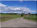
Track to Cairnston
Image: © Dominic Dawn Harry and Jacob Paterson
Taken: 3 Jun 2006
0.05 miles
2
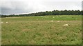
Sheep, Cairnston
Sheep grazing beside the access road to Cairnston itself, appears to be no longer a farm.
Image: © Richard Webb
Taken: 3 Sep 2008
0.11 miles
3
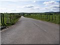
Deadend Road to Ashfield
Image: © Dominic Dawn Harry and Jacob Paterson
Taken: 3 Jun 2006
0.15 miles
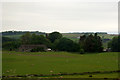
5
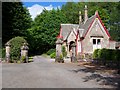
Gatehouse for Glassingall
Image: © Dominic Dawn Harry and Jacob Paterson
Taken: 3 Jun 2006
0.24 miles