IMAGES TAKEN NEAR TO
Leighton Court, DUNBLANE, FK15 0ED
Introduction
This page details the photographs taken nearby to Leighton Court, FK15 0ED by members of the Geograph project.
The Geograph project started in 2005 with the aim of publishing, organising and preserving representative images for every square kilometre of Great Britain, Ireland and the Isle of Man.

There are currently over 7.5m images from over14,400 individuals and you can help contribute to the project by visiting https://www.geograph.org.uk
Image Map
Images are licensed for reuse under creativecommons.org/licenses/by-sa/2.0
Notes
- Clicking on the map will re-center to the selected point.
- The higher the marker number, the further away the image location is from the centre of the postcode.
Image Listing (7 Images Found)
Images are licensed for reuse under creativecommons.org/licenses/by-sa/2.0
Image
Details
Distance
1
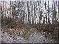
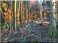
Dykedale Wood
A path into some woodland on the edge of Dunblane. The wood is next to houses and there are limited access points from below.
Image: © Richard Webb
Taken: 30 Nov 2012
0.06 miles
2
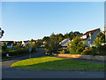
Dykedale, Dunblane
A suburban street of late 20th century housing.
Image: © Stephen Craven
Taken: 27 Jun 2019
0.18 miles
4
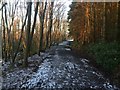
Path, Dykedale Wood
On the edge of Dunblane, a town with a lot of easily accessible woodland around and within it.
Image: © Richard Webb
Taken: 30 Jan 2019
0.20 miles
5
Dykedale Wood, Dunblane
On the edge of town, below Sheriffmuir.
Image: © Richard Webb
Taken: 30 Jan 2019
0.22 miles
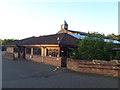
6
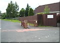
Newton Primary School
Newton School entrance off Newton Crescent.
Image: © Derek Ferris
Taken: 7 Jul 2007
0.24 miles
7
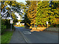
Newton Crescent, Dunblane
The start of a 20mph speed limit zone.
Image: © Stephen Craven
Taken: 27 Jun 2019
0.24 miles