IMAGES TAKEN NEAR TO
Buccleuch Court, DUNBLANE, FK15 0AR
Introduction
This page details the photographs taken nearby to Buccleuch Court, FK15 0AR by members of the Geograph project.
The Geograph project started in 2005 with the aim of publishing, organising and preserving representative images for every square kilometre of Great Britain, Ireland and the Isle of Man.

There are currently over 7.5m images from over14,400 individuals and you can help contribute to the project by visiting https://www.geograph.org.uk
Image Map
Images are licensed for reuse under creativecommons.org/licenses/by-sa/2.0
Notes
- Clicking on the map will re-center to the selected point.
- The higher the marker number, the further away the image location is from the centre of the postcode.
Image Listing (385 Images Found)
Images are licensed for reuse under creativecommons.org/licenses/by-sa/2.0
Image
Details
Distance
2
Allan Water in spate by the railway bridge
Image: © Jonathan Thacker
Taken: 21 Feb 2020
0.05 miles
3
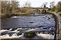
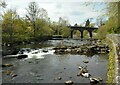
Viaduct, Dunblane
Carrying the railway from Stirling to Perth over the Allan Water. The path is a popular route to the large open space of Laigh Hills.
Image: © Richard Webb
Taken: 13 Feb 2018
0.05 miles
4

Allan Water, Dunblane
The river descends steeply through Dunblane and must have been an important source of power for industry at one time. The viaduct carries the railway between Perth and Stirling.
Image: © Richard Webb
Taken: 13 Feb 2018
0.05 miles
5
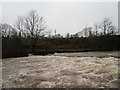
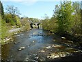
Weir on the Allan Water, Dunblane
There is so much water coming down the river that the weir is almost overwhelmed.
Image: © Jonathan Thacker
Taken: 21 Feb 2020
0.05 miles
6
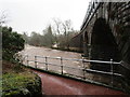
Allan Water
Looking upstream to the weir and the Dunblane Railway Viaduct. The weir used to hold back water to power the former Springbank Mill Image
Image: © Richard Sutcliffe
Taken: 29 Apr 2022
0.05 miles
7
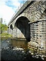
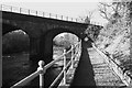
Viaduct over the Allan Water
Officially it's Bridge SCM4 133/001, according to a small sign attached to one of the supports Image It dates from 1846-8 and was built for the Scottish Central Railway. It is Category B listed http://portal.historicenvironment.scot/designation/LB26425.
Image: © Richard Sutcliffe
Taken: 29 Apr 2022
0.05 miles
8
Dunblane Railway Viaduct
Looking downstream from the Faery Bridge to the viaduct over the Allan Water which dates from 1846-8 and was built for the Scottish Central Railway. It is Category B listed http://portal.historicenvironment.scot/designation/LB26425.
Image: © Richard Sutcliffe
Taken: 29 Apr 2022
0.05 miles
9
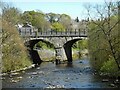
Dunblane Railway Viaduct
A zoomed view from the Faery Bridge to the viaduct over the Allan Water which dates from 1846-8 and was built for the Scottish Central Railway. It is Category B listed http://portal.historicenvironment.scot/designation/LB26425.
Image: © Richard Sutcliffe
Taken: 29 Apr 2022
0.05 miles