
IMAGES TAKEN NEAR TO
Tamfourhill Road, FALKIRK, FK1 4RA
Introduction
This page details the photographs taken nearby to Tamfourhill Road, FK1 4RA by members of the Geograph project.
The Geograph project started in 2005 with the aim of publishing, organising and preserving representative images for every square kilometre of Great Britain, Ireland and the Isle of Man.

There are currently over 7.5m images from over14,400 individuals and you can help contribute to the project by visiting https://www.geograph.org.uk
Image Map
Images are licensed for reuse under creativecommons.org/licenses/by-sa/2.0
Notes
- Clicking on the map will re-center to the selected point.
- The higher the marker number, the further away the image location is from the centre of the postcode.
Image Listing (47 Images Found)
Images are licensed for reuse under creativecommons.org/licenses/by-sa/2.0
Image
Details
Distance
1
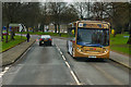
Bus on Glenfuir Road
First Scotland 67780 (SN62 AYA), an Alexander Dennis Enviro 300 low floor bus on Glenfuir Road in Falkirk operating on route 6 to Forth Valley Royal Hospital.
Image: © David Dixon
Taken: 5 Mar 2020
0.07 miles
2
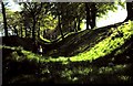
Antonine's Wall at Watling Lodge
Antonine's Wall running across central Scotland from the Forth to the Clyde was built in 142AD and is 37 miles long. It marked the northern frontier of the Roman Empire but was soon abandoned. The photo shows the ditch in advance of the wall with upcast mound to the left and ramparts to the right.Since it was built of turf on stone foundations much of the wall has been eroded but sections here also at Rough Castle and over Barr Hill are well preserved. It is now listed as a World Heritage Site.
Image: © ronnie leask
Taken: Unknown
0.07 miles
4
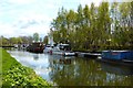
Port Downie
This used to be a very busy place when it was the junction of the Forth & Clyde and Union Canals. Nowadays the junction is at the boat lift further west.
Image: © Robert Murray
Taken: 9 May 2015
0.10 miles
5
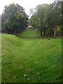
Antonine Wall at Watling Lodge
The ditch and ramparts which are the remains of the Antonine Wall
Image: © Darrin Antrobus
Taken: 25 Sep 2012
0.11 miles
6
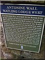
Antonine Wall Info from Historic Scotland
Plaque at Watling Lodge
Image: © Darrin Antrobus
Taken: 25 Sep 2012
0.11 miles
8
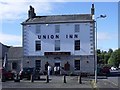
Union Inn, Falkirk
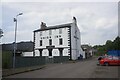
Situated at the former junction of the Union and Forth & Clyde canals, it takes its name from the former. Some of the regulars can be observed having an alfresco smoke.
Image: © Robert Murray
Taken: 18 Sep 2010
0.11 miles
9

Towpath along the Forth and Clyde Canal
In the Camelon area of Falkirk.
Image: © Mat Fascione
Taken: 2 Jun 2016
0.12 miles
10
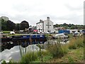
Union Inn near Lock 16
The Union Canal from Edinburgh joined the Forth and Clyde here in 1822. The Union Inn was built beside the basin to cater for boat passengers travelling between Glasgow and Edinburgh.
Image: © Eirian Evans
Taken: 10 Sep 2021
0.12 miles