IMAGES TAKEN NEAR TO
Greenbank Place, FALKIRK, FK1 4AL
Introduction
This page details the photographs taken nearby to Greenbank Place, FK1 4AL by members of the Geograph project.
The Geograph project started in 2005 with the aim of publishing, organising and preserving representative images for every square kilometre of Great Britain, Ireland and the Isle of Man.

There are currently over 7.5m images from over14,400 individuals and you can help contribute to the project by visiting https://www.geograph.org.uk
Image Map
Images are licensed for reuse under creativecommons.org/licenses/by-sa/2.0
Notes
- Clicking on the map will re-center to the selected point.
- The higher the marker number, the further away the image location is from the centre of the postcode.
Image Listing (65 Images Found)
Images are licensed for reuse under creativecommons.org/licenses/by-sa/2.0
Image
Details
Distance
1
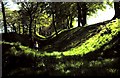
Antonine's Wall at Watling Lodge
Antonine's Wall running across central Scotland from the Forth to the Clyde was built in 142AD and is 37 miles long. It marked the northern frontier of the Roman Empire but was soon abandoned. The photo shows the ditch in advance of the wall with upcast mound to the left and ramparts to the right.Since it was built of turf on stone foundations much of the wall has been eroded but sections here also at Rough Castle and over Barr Hill are well preserved. It is now listed as a World Heritage Site.
Image: © ronnie leask
Taken: Unknown
0.11 miles
2
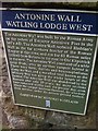
Antonine Wall Info from Historic Scotland
Plaque at Watling Lodge
Image: © Darrin Antrobus
Taken: 25 Sep 2012
0.11 miles
4
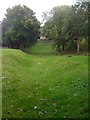
Antonine Wall at Watling Lodge
The ditch and ramparts which are the remains of the Antonine Wall
Image: © Darrin Antrobus
Taken: 25 Sep 2012
0.12 miles
6
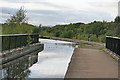
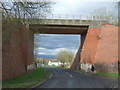
New Aqueduct and Basin
One of the advantages of this new aqueduct is that the towpath is smooth, not cobbled, making it easier and safer to cycle across this than across the original cobbled ones.
Image: © Anne Burgess
Taken: 5 Oct 2013
0.12 miles
7
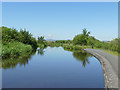
Westward extension of the Union Canal
This is part of the extension opened in 2002 to link to the Falkirk Wheel.
Image: © Stephen Craven
Taken: 27 Jun 2019
0.13 miles
8
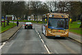
Bus on Glenfuir Road
First Scotland 67780 (SN62 AYA), an Alexander Dennis Enviro 300 low floor bus on Glenfuir Road in Falkirk operating on route 6 to Forth Valley Royal Hospital.
Image: © David Dixon
Taken: 5 Mar 2020
0.13 miles
9
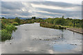
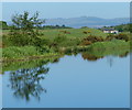
Union Canal near Tamfourhill
The vegetation has colonised the sides of the new stretch of canal with such alacrity that you would never know it is new. I was interested to observe a gentle eddy in the widest part of the canal here, where water flowing west from the aqueduct seemed to be coming to a halt. The assorted twigs and leaves in the water mark the spot. Fantastic sky, too: classic mountain lee wave set up by strong winds blowing over the mountains from the west.
Image: © Anne Burgess
Taken: 5 Oct 2013
0.13 miles
10
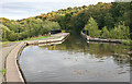
Basin and New Aqueduct
I was interested to observe a gentle eddy in the widest part of the canal here, where water flowing west from the aqueduct seemed to be coming to a halt. The assorted twigs and leaves in the water mark the spot.
Image: © Anne Burgess
Taken: 5 Oct 2013
0.13 miles