IMAGES TAKEN NEAR TO
Slamannan, FALKIRK, FK1 3BX
Introduction
This page details the photographs taken nearby to FK1 3BX by members of the Geograph project.
The Geograph project started in 2005 with the aim of publishing, organising and preserving representative images for every square kilometre of Great Britain, Ireland and the Isle of Man.

There are currently over 7.5m images from over14,400 individuals and you can help contribute to the project by visiting https://www.geograph.org.uk
Image Map
Images are licensed for reuse under creativecommons.org/licenses/by-sa/2.0
Notes
- Clicking on the map will re-center to the selected point.
- The higher the marker number, the further away the image location is from the centre of the postcode.
Image Listing (6 Images Found)
Images are licensed for reuse under creativecommons.org/licenses/by-sa/2.0
Image
Details
Distance
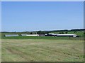
![Whiteside Farm [2]](https://s2.geograph.org.uk/geophotos/02/52/76/2527698_3fbc9cb0_120x120.jpg)
3
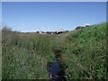
The North Calder's little Valley
To be more precise the North Calder from source to the Clyde flows through an incised river valley.
Image: © Robert Murray
Taken: 24 Jul 2011
0.17 miles
5
Wester Whin Farm
More correctly 'New' Wester Whin.
Image: © Robert Murray
Taken: 24 Jul 2011
0.21 miles
6
The North Calder Water, Wester Whin
Steep banks on either side of the little burn that in these parts marks the boundary of Falkirk (right) and North Lanarkshire (left).
Note to owner of Whiteside Farm. Are you sure you need a ridiculously high fence interwoven with enough barbed wire to lace the Korean border? Are you expecting an invasion? Or do you just not like walkers ......
Image: © Robert Murray
Taken: 24 Jul 2011
0.22 miles