IMAGES TAKEN NEAR TO
Bard's Way, TILLICOULTRY, FK13 6RY
Introduction
This page details the photographs taken nearby to Bard's Way, FK13 6RY by members of the Geograph project.
The Geograph project started in 2005 with the aim of publishing, organising and preserving representative images for every square kilometre of Great Britain, Ireland and the Isle of Man.

There are currently over 7.5m images from over14,400 individuals and you can help contribute to the project by visiting https://www.geograph.org.uk
Image Map
Images are licensed for reuse under creativecommons.org/licenses/by-sa/2.0
Notes
- Clicking on the map will re-center to the selected point.
- The higher the marker number, the further away the image location is from the centre of the postcode.
Image Listing (7 Images Found)
Images are licensed for reuse under creativecommons.org/licenses/by-sa/2.0
Image
Details
Distance
1
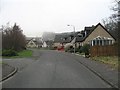
Bard's Way
Well spaced residential area on the edge of Tillicoultry.
Image: © Richard Webb
Taken: 11 Feb 2008
0.03 miles
2
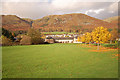
Harviestoun Country Hotel
The steadings of the former Harviestoun Mains farm, now trading as a hotel, restaurant and function suite.
Image: © John Allan
Taken: 31 Oct 2009
0.05 miles
3
The Harviestoun Country Hotel & Restaurant
A steading converted into a hotel.
Image: © Richard Webb
Taken: 11 Feb 2008
0.05 miles
4
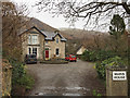
Mains House, Harviestoun
Formerly the farmhouse of Harviestoun Mains.
Image: © John Allan
Taken: 11 Feb 2017
0.09 miles
5
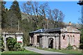
West Lodge at drive leading to Harviestoun Home Farm
Image: © Leslie Barrie
Taken: 18 Apr 2014
0.15 miles
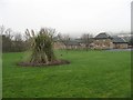
6
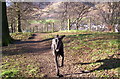
Midge enjoying a walk at the 'Bunny Hill', Tillicoultry.
Disused sand pit beyond fenceline now overgrown with beach woodland and scrub, known locally as 'The Bunny Hill'. Former site of a Druidical Temple where stone cists were found in 1898. Sadly now there is only a mobile phone mast on the site.
Image: © John Chroston
Taken: Unknown
0.21 miles
7
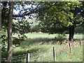
Harviestoun Home Farm
Fields below the farm house
Image: © Angela Mudge
Taken: 17 Jul 2006
0.25 miles