IMAGES TAKEN NEAR TO
Hawthorne Avenue, TILLICOULTRY, FK13 6LA
Introduction
This page details the photographs taken nearby to Hawthorne Avenue, FK13 6LA by members of the Geograph project.
The Geograph project started in 2005 with the aim of publishing, organising and preserving representative images for every square kilometre of Great Britain, Ireland and the Isle of Man.

There are currently over 7.5m images from over14,400 individuals and you can help contribute to the project by visiting https://www.geograph.org.uk
Image Map
Images are licensed for reuse under creativecommons.org/licenses/by-sa/2.0
Notes
- Clicking on the map will re-center to the selected point.
- The higher the marker number, the further away the image location is from the centre of the postcode.
Image Listing (9 Images Found)
Images are licensed for reuse under creativecommons.org/licenses/by-sa/2.0
Image
Details
Distance
1
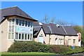
Coalsnaughton Village Hall & Internet Cafe
Village hall and library built 1907 with funding from Andrew Carnegie. Lesser hall added in 1925.
Image: © Leslie Barrie
Taken: 18 Apr 2014
0.05 miles
4
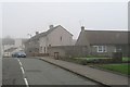
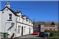
Coalsnaughton
As suggested by the name, a former mining village.
Image: © Richard Webb
Taken: 11 Feb 2008
0.08 miles
5
Main Street & Mount Pleasant, Coalsnaughton
Image: © Leslie Barrie
Taken: 18 Apr 2014
0.09 miles
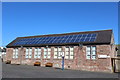
6
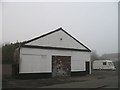
"Resting" building, Coalsnaughton
Does not appear to be in use at the time of visit.
Image: © Richard Webb
Taken: 11 Feb 2008
0.10 miles
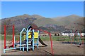
7
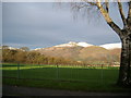
Coalsnaughton football pitch
The Ochils at the rear - Ben Cleugh, mainly
Image: © Kirsty Smith
Taken: 29 Nov 2005
0.20 miles
8
Coalsnaughton
Eastern edge of Coalsnaughton (incidentally, pronounced Clsnawtn).
Image: © Kirsty Smith
Taken: 29 Nov 2005
0.21 miles
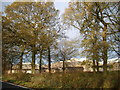
9
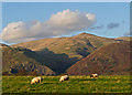
Farmland near Coalsnaughton
Grazing land near Coalsnaughton, with the Ochil Hills and Tillicoultry quarry visible in the distance.
Image: © William Starkey
Taken: 12 Nov 2011
0.22 miles