IMAGES TAKEN NEAR TO
Upper Mill Street, TILLICOULTRY, FK13 6AY
Introduction
This page details the photographs taken nearby to Upper Mill Street, FK13 6AY by members of the Geograph project.
The Geograph project started in 2005 with the aim of publishing, organising and preserving representative images for every square kilometre of Great Britain, Ireland and the Isle of Man.

There are currently over 7.5m images from over14,400 individuals and you can help contribute to the project by visiting https://www.geograph.org.uk
Image Map
Images are licensed for reuse under creativecommons.org/licenses/by-sa/2.0
Notes
- Clicking on the map will re-center to the selected point.
- The higher the marker number, the further away the image location is from the centre of the postcode.
Image Listing (47 Images Found)
Images are licensed for reuse under creativecommons.org/licenses/by-sa/2.0
Image
Details
Distance
1
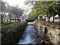
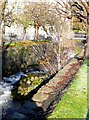
Gannel Burn
Near to the Old Mill in Tillicoultry Glen.
Image: © Iain Russell
Taken: 20 Aug 2019
0.02 miles
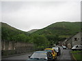
2
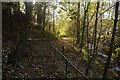
Gate at the foot of the Mill Glen
The Mill Glen has been closed for about 5 years due to unstable rock, possibly connected to the death of many elm trees on the crags. While not officially open yet, the barriers have been taken down and a reengineered path is walkable to the confluence at the foot of The Law. Some work remains in progress, but the heavy rock bolting and chaining seems to have ceased. It looks like a good job, and the path remains spectacular, as I remember it.
Image: © Richard Webb
Taken: 5 Nov 2016
0.03 miles
4
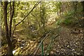
Mill Glen, Tillicoultry
The path is accessible again after a long closure due to rockfall and unstable crags. Work continues but the barriers have been taken down.
Image: © Richard Webb
Taken: 5 Nov 2016
0.04 miles
5
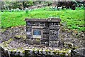
Memorial to Arthur Bracewell
Arthur Bracewell was the Burgh Architect of Tillicoultry and designed many of the mill buildings and workers' dwellings. He also opened up Tillicoultry Glen by constructing paths and bridges, employing the labour of unemployed mill workers.
Image: © Robert Struthers
Taken: 29 Apr 2018
0.04 miles
6
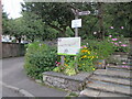
Hillfoots Diamond Jubilee Way information sign
Information sign and map at the top of Upper Mill Street in Tillicoultry, on part of the Hillfoots Diamond Jubilee Way walking trail.
Image: © Scott Cormie
Taken: 30 Aug 2020
0.04 miles
7
The Tillicoultry Burn at Tillicoultrie
Or is it the Gannel Burn - OS mapping is unclear?
Image: © Gordon Brown
Taken: 9 Nov 2009
0.04 miles
9
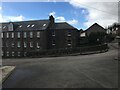
Braehead Avenue , Tillicoultry
Clock Mill visible in the centre, started out as a mill and after various uses now serves residential purposes.The snowy top of Kirk Craigs showing behind the mill.
Image: © Dan
Taken: 8 Mar 2009
0.06 miles
10
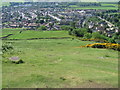
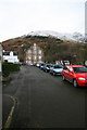
Mill Street, Tillicoultry
Start of the walk across the Ochils to Blackford
Image: © Robert Smallman
Taken: 28 Jun 2008
0.07 miles