IMAGES TAKEN NEAR TO
Standburn Road, FALKIRK, FK1 2NY
Introduction
This page details the photographs taken nearby to Standburn Road, FK1 2NY by members of the Geograph project.
The Geograph project started in 2005 with the aim of publishing, organising and preserving representative images for every square kilometre of Great Britain, Ireland and the Isle of Man.

There are currently over 7.5m images from over14,400 individuals and you can help contribute to the project by visiting https://www.geograph.org.uk
Image Map
Images are licensed for reuse under creativecommons.org/licenses/by-sa/2.0
Notes
- Clicking on the map will re-center to the selected point.
- The higher the marker number, the further away the image location is from the centre of the postcode.
Image Listing (15 Images Found)
Images are licensed for reuse under creativecommons.org/licenses/by-sa/2.0
Image
Details
Distance
1
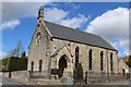
Avonbridge Parish Church of Scotland
Built 1804
Image: © Leslie Barrie
Taken: 4 May 2015
0.04 miles
2
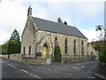
Avonbridge Parish Church, Avonbridge
A simple traditional church at the northern end of the village of Avonbridge.
The road to the left is the B8028 (Falkirk Road) leading to Falkirk while the road to the right is the B825 (Standburn Road) leading to Linlithgow.
Image: © G Laird
Taken: 20 Oct 2017
0.04 miles
3

NEW
Avonbridge parish church
At the junction of the B825 and B8028 in the northern part of the village.
Image: © M J Richardson
Taken: 12 Mar 2025
0.04 miles
4
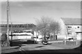
Avonbridge
Looking north to the bridge.
Image: © Richard Webb
Taken: 28 Nov 2005
0.08 miles
5
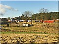
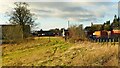
Railway embankment Avonbridge
After a lunch stop in Avonbridge during a Slamannan to Whitecross railway walk, the next section continued along an embankment above Blackston Road. The embankment can be made out heading from the gable of the building centre left edge to the centre right edge of the photo in front of a road haulier's storage area.
Image: © AlastairG
Taken: 27 Jan 2022
0.10 miles
6
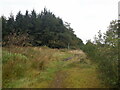
Disused L&NER route at Avonbridge
The flat grass area behind the fence left of centre is part of the route shown in Image
Image: © AlastairG
Taken: 27 Jan 2022
0.11 miles
8
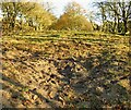
Abandoned L&NER route east of Avonbridge
The route east of Avonbridge climbs a gentle incline. The track runs straight ahead between the trees on the left and right sides of the photo. The disturbed surface in the foreground showed a mixture of very coarse sand with a few pieces of old metal in it.
Image: © AlastairG
Taken: 27 Jan 2022
0.19 miles
9
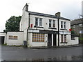
The Avonside Inn
A potential for lunch when I was planning my day out, but obviously not a good idea. It still seemed to have been open when Google Car passed in 2009.
Image: © M J Richardson
Taken: 14 Aug 2012
0.19 miles
10
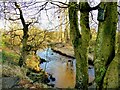
River Avon from Avonbridge park
This small public park is slotted in between the River Avon and the back road to Westfield. Although small, it had the luxury of a comfortable bench which provided an ideal lunch stop on the walk from Slamannan to Whitecross. If you want something more substantial than the contents of your backpack, there is a community run cafe opposite the gate into the park. It provides a varied menu of snacks and cooked lunches.
Image: © AlastairG
Taken: 27 Jan 2022
0.23 miles