IMAGES TAKEN NEAR TO
Bridgend Road, FALKIRK, FK1 2NU
Introduction
This page details the photographs taken nearby to Bridgend Road, FK1 2NU by members of the Geograph project.
The Geograph project started in 2005 with the aim of publishing, organising and preserving representative images for every square kilometre of Great Britain, Ireland and the Isle of Man.

There are currently over 7.5m images from over14,400 individuals and you can help contribute to the project by visiting https://www.geograph.org.uk
Image Map
Images are licensed for reuse under creativecommons.org/licenses/by-sa/2.0
Notes
- Clicking on the map will re-center to the selected point.
- The higher the marker number, the further away the image location is from the centre of the postcode.
Image Listing (6 Images Found)
Images are licensed for reuse under creativecommons.org/licenses/by-sa/2.0
Image
Details
Distance
1
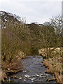
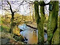
View from a bridge on the River Avon
A view of the River Avon from a footbridge on the Avon Heritage Trail. This waymarked route runs for 14km between Avonbridge and Linlithgow. The Avon itself flows from the south east of Cumbernauld, and enters the Forth at Kinneil.
Image: © William Starkey
Taken: 12 Feb 2012
0.09 miles
2
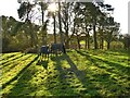
Country companions
Two horses and a pair of camera shy donkeys share the grazing in an enclosure beside the abandoned route of the L&NER line east of Avonbridge.
Image: © AlastairG
Taken: 27 Jan 2022
0.16 miles
3
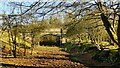
Bridge over abandoned L&NER track
A bit of a 'Shenavall' bridge with the north approach in one square and the south in another. The bridge carries a farm track and judging by 19th century maps, it seems that was its original purpose, rather than for a mineral line. See Image] for detailed work on the bridge.
Image: © AlastairG
Taken: 27 Jan 2022
0.17 miles
4
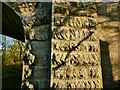
Masonry detail on Victorian bridge
This is the bridge in Image A bridge carrying a farm track over a goods line in the middle of nowhere and yet this much detail was added. The Victorians certainly had style.
Image: © AlastairG
Taken: 27 Jan 2022
0.17 miles
5
River Avon from Avonbridge park
This small public park is slotted in between the River Avon and the back road to Westfield. Although small, it had the luxury of a comfortable bench which provided an ideal lunch stop on the walk from Slamannan to Whitecross. If you want something more substantial than the contents of your backpack, there is a community run cafe opposite the gate into the park. It provides a varied menu of snacks and cooked lunches.
Image: © AlastairG
Taken: 27 Jan 2022
0.18 miles
6
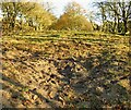
Abandoned L&NER route east of Avonbridge
The route east of Avonbridge climbs a gentle incline. The track runs straight ahead between the trees on the left and right sides of the photo. The disturbed surface in the foreground showed a mixture of very coarse sand with a few pieces of old metal in it.
Image: © AlastairG
Taken: 27 Jan 2022
0.23 miles