IMAGES TAKEN NEAR TO
Avonbridge, FALKIRK, FK1 2JX
Introduction
This page details the photographs taken nearby to FK1 2JX by members of the Geograph project.
The Geograph project started in 2005 with the aim of publishing, organising and preserving representative images for every square kilometre of Great Britain, Ireland and the Isle of Man.

There are currently over 7.5m images from over14,400 individuals and you can help contribute to the project by visiting https://www.geograph.org.uk
Image Map
Images are licensed for reuse under creativecommons.org/licenses/by-sa/2.0
Notes
- Clicking on the map will re-center to the selected point.
- The higher the marker number, the further away the image location is from the centre of the postcode.
Image Listing (10 Images Found)
Images are licensed for reuse under creativecommons.org/licenses/by-sa/2.0
Image
Details
Distance
1
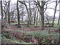
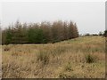
Woodland, Easter Rigghead
A small wood with no boundary with the neighbouring field.
Image: © Richard Webb
Taken: 9 Jan 2009
0.05 miles
2
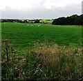
Sheep grazing
Grazing on second growth of grass after a cut of silage/hay
Image: © Jim Smillie
Taken: 12 Aug 2021
0.12 miles
3
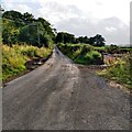
More room required
This minor road not quite wide enough to accommodate farmer turning in and out of field
Image: © Jim Smillie
Taken: 12 Aug 2021
0.15 miles
4
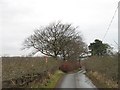
Minor road, Rigghead
A muddy lane serving farmland on the Slamannan Plateau near Avonbridge. The red and white marker shows the course of a gas pipeline.
Image: © Richard Webb
Taken: 9 Jan 2009
0.18 miles
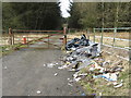
5
Reservoir and electricity substation access
Some of the locals clearly cannot read!
Image: © M J Richardson
Taken: 21 Mar 2020
0.18 miles
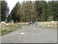
6
The undiminishing tide of litter
At the access to an electricity sub station and reservoir near Avonbridge.
Image: © M J Richardson
Taken: 21 Mar 2020
0.18 miles
7
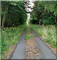
Track through wooded area
Access to covered reservoir and electricity sub-station
Image: © Jim Smillie
Taken: 12 Aug 2021
0.18 miles
8
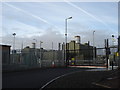
Gas pipeline compressor Station, Avonbridge
This area is crossed by several major gas pipelines. This is a large well protected facility
Image: © paul birrell
Taken: 2 Jan 2006
0.21 miles
9
North Rhodes Plantation
A young plantation, part of the Central Scotland Forest project.
Image: © Richard Webb
Taken: 31 Jan 2014
0.21 miles
10

Fields at Linhouse
Looking across Lin Mill Burn to an old quarry.
Image: © M J Richardson
Taken: 21 Mar 2020
0.22 miles