IMAGES TAKEN NEAR TO
Avonbridge, FALKIRK, FK1 2JL
Introduction
This page details the photographs taken nearby to FK1 2JL by members of the Geograph project.
The Geograph project started in 2005 with the aim of publishing, organising and preserving representative images for every square kilometre of Great Britain, Ireland and the Isle of Man.

There are currently over 7.5m images from over14,400 individuals and you can help contribute to the project by visiting https://www.geograph.org.uk
Image Map
Images are licensed for reuse under creativecommons.org/licenses/by-sa/2.0
Notes
- Clicking on the map will re-center to the selected point.
- The higher the marker number, the further away the image location is from the centre of the postcode.
Image Listing (19 Images Found)
Images are licensed for reuse under creativecommons.org/licenses/by-sa/2.0
Image
Details
Distance
2
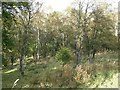
Woodland, Babbithill
Open birchwood which is grazed and has some large clearings.
Image: © Richard Webb
Taken: 8 Oct 2009
0.08 miles
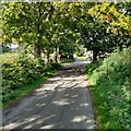
3
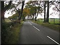
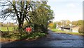
Beech lined road, Babbithill
The B825 to Caldercruix from Avonbridge.
Image: © Richard Webb
Taken: 8 Oct 2009
0.09 miles
5
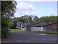
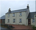
Kennels
Hyndford Kennels and Cattery at Crossroads.
Image: © Callum Black
Taken: 3 Jun 2006
0.11 miles
6
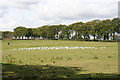
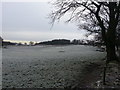
A Parliament of Gulls
I wonder why all the gulls have settled in one area of the field instead of spreading themselves right across it?
Image: © Anne Burgess
Taken: 25 Aug 2015
0.13 miles
7
Crossroads, Babbithill
New signs for a wind farm construction project somewhere near Burnhead.
Image: © Richard Webb
Taken: 17 Oct 2014
0.14 miles
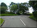
10
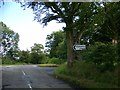
Slightly staggered junction
On to B8022 after crossing B825
Image: © Jim Smillie
Taken: 7 Sep 2021
0.15 miles