IMAGES TAKEN NEAR TO
Glebe Road, ALLOA, FK10 4QB
Introduction
This page details the photographs taken nearby to Glebe Road, FK10 4QB by members of the Geograph project.
The Geograph project started in 2005 with the aim of publishing, organising and preserving representative images for every square kilometre of Great Britain, Ireland and the Isle of Man.

There are currently over 7.5m images from over14,400 individuals and you can help contribute to the project by visiting https://www.geograph.org.uk
Image Map
Images are licensed for reuse under creativecommons.org/licenses/by-sa/2.0
Notes
- Clicking on the map will re-center to the selected point.
- The higher the marker number, the further away the image location is from the centre of the postcode.
Image Listing (31 Images Found)
Images are licensed for reuse under creativecommons.org/licenses/by-sa/2.0
Image
Details
Distance
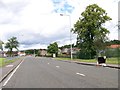
1
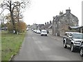
Kilbagie Street
An old bit of main road, now replaced by a more modern road to the east.
Image: © Richard Webb
Taken: 15 Oct 2009
0.09 miles
3
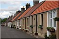
Cottages
Row of cottages in Hawkhill Road Kincardine.
Image: © Paul McIlroy
Taken: 17 Jun 2007
0.14 miles
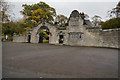
6
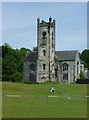
Kincardine Parish Church
Viewed across primary school playing fields.
Image: © kim traynor
Taken: 20 Jun 2013
0.15 miles
8
Tulliallan and Kincardine Parish Church
Image: © Richard Webb
Taken: 5 Nov 2016
0.15 miles
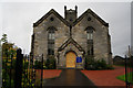
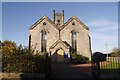
9
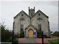
Tulliallan Parish Church
Dates from 1832-33.
Image: © Jonathan Thacker
Taken: 17 Aug 2018
0.15 miles
