IMAGES TAKEN NEAR TO
Devonway, CLACKMANNAN, FK10 4LE
Introduction
This page details the photographs taken nearby to Devonway, FK10 4LE by members of the Geograph project.
The Geograph project started in 2005 with the aim of publishing, organising and preserving representative images for every square kilometre of Great Britain, Ireland and the Isle of Man.

There are currently over 7.5m images from over14,400 individuals and you can help contribute to the project by visiting https://www.geograph.org.uk
Image Map
Images are licensed for reuse under creativecommons.org/licenses/by-sa/2.0
Notes
- Clicking on the map will re-center to the selected point.
- The higher the marker number, the further away the image location is from the centre of the postcode.
Image Listing (22 Images Found)
Images are licensed for reuse under creativecommons.org/licenses/by-sa/2.0
Image
Details
Distance
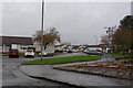
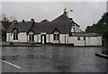
3
B910, edge of Clackmannan
Entering Clackmannan from the Alloa direction.
Image: © Richard Webb
Taken: 18 Sep 2009
0.14 miles
4
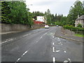
The B910 road heading out of Clackmannan
The old county town of the county of the same name,
Image: © James Denham
Taken: 28 May 2011
0.14 miles
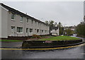
7
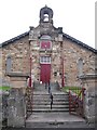
Lodge Clackmannan
No. 1303, on Kirk Wynd.
Image: © Richard Webb
Taken: 18 Sep 2009
0.16 miles
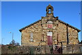
8
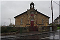
Clackmannan Masonic Lodge, #1303
Erected 4th February 1923.
Image: © Ian S
Taken: 23 Oct 2014
0.16 miles
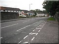
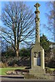
10
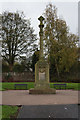
Clackmannan War Memorial
On Kerse Green Road.
Image: © Ian S
Taken: 23 Oct 2014
0.17 miles