IMAGES TAKEN NEAR TO
Lochies Road, CLACKMANNAN, FK10 4EN
Introduction
This page details the photographs taken nearby to Lochies Road, FK10 4EN by members of the Geograph project.
The Geograph project started in 2005 with the aim of publishing, organising and preserving representative images for every square kilometre of Great Britain, Ireland and the Isle of Man.

There are currently over 7.5m images from over14,400 individuals and you can help contribute to the project by visiting https://www.geograph.org.uk
Image Map
Images are licensed for reuse under creativecommons.org/licenses/by-sa/2.0
Notes
- Clicking on the map will re-center to the selected point.
- The higher the marker number, the further away the image location is from the centre of the postcode.
Image Listing (28 Images Found)
Images are licensed for reuse under creativecommons.org/licenses/by-sa/2.0
Image
Details
Distance
1
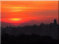
Clackmannanshire sunset
A January sunset over the town of Clackmannan, with the church tower visible towards the right of the image.
Image: © William Starkey
Taken: 15 Jan 2012
0.08 miles
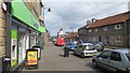
2
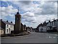
Clackmannan Market Place
The village that Scotland's smallest county took its name from. View is looking down the main street of the town with the Mercat Cross and old Tolbooth with the clock on it visible, also visible is the large boulder just to the right of the cross which is known as the "Clack" or stone of Mannan which is named after the Celtic God Manau and after which the town takes its name.
Image: © Kevin Rae
Taken: 26 Jul 2005
0.12 miles
3
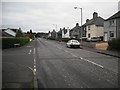
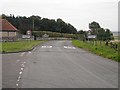
Alloa Road
Former main road, now replaced by a bypass, leaving Clackmannan towards Fife.
Image: © Richard Webb
Taken: 15 Oct 2009
0.18 miles
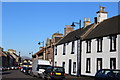
4
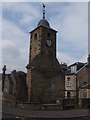
Clackmannan Tollbooth & Clock Tower
The tollbooth was built in 1592 and originally comprised a prison, court room and jailer's house. The Stone of Mannan (Clach - Clack in Gaelic means stone) is adjacent to the tollbooth set atop a monolith. Who Mannan was is obscure.
Image: © ronnie leask
Taken: 12 Apr 2008
0.19 miles
6
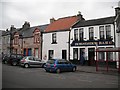
Horseshoe Bar
Main Street, Clackmannan
Image: © Richard Webb
Taken: 18 Sep 2009
0.20 miles
9
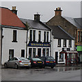
The Horseshoe Bar on Main Street, Clackmannan
Image: © Ian S
Taken: 23 Oct 2014
0.21 miles
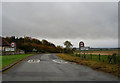
10
Cycle Friendly Road
Well from here at the Clackmannan end it is. It is not quite so friendly climbing Lookaboutye Brae from the carse.
Lookaboutye Brae is part of the National Cycle Network's route 76.
Image: © Richard Webb
Taken: 18 Sep 2009
0.21 miles