IMAGES TAKEN NEAR TO
Kilbagie, ALLOA, FK10 4DY
Introduction
This page details the photographs taken nearby to FK10 4DY by members of the Geograph project.
The Geograph project started in 2005 with the aim of publishing, organising and preserving representative images for every square kilometre of Great Britain, Ireland and the Isle of Man.

There are currently over 7.5m images from over14,400 individuals and you can help contribute to the project by visiting https://www.geograph.org.uk
Image Map
Images are licensed for reuse under creativecommons.org/licenses/by-sa/2.0
Notes
- Clicking on the map will re-center to the selected point.
- The higher the marker number, the further away the image location is from the centre of the postcode.
Image Listing (7 Images Found)
Images are licensed for reuse under creativecommons.org/licenses/by-sa/2.0
Image
Details
Distance
1
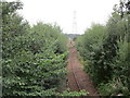
Railway to Dunfermline at Kilbagie
The line is not in regular use but there is occasional talk of opening a passenger service from Alloa to Dunfermline.
Image: © Jonathan Thacker
Taken: 17 Aug 2018
0.05 miles
2
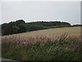
Bank of Rosebay Willowherb at Kilbagie
Image: © Jonathan Thacker
Taken: 17 Aug 2018
0.07 miles
3
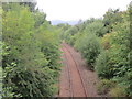
Railway to Alloa at Kilbagie
Not in regular use though there is occasional talk of re-opening to passengers with a service from Alloa to Dunfermline.
Image: © Jonathan Thacker
Taken: 17 Aug 2018
0.11 miles
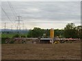
4
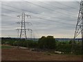
Pylons, near Kilbaggie
The railway beyond is being refurbished and will reopen in 2007.
Image: © Richard Webb
Taken: 4 Jun 2006
0.22 miles
5
Kilbagie
The bridge is on the gridline. Workers on the soon to be reopened Kincardine to Stirling railway.
Image: © Richard Webb
Taken: 4 Jun 2006
0.22 miles
6
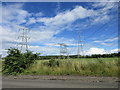
Multitude of pylons
Pylons on the A977 at the Clackmannan/Fife border.
Image: © Scott Cormie
Taken: 5 Aug 2017
0.22 miles
7
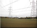
Pylons, near Kilbaggie
Three power lines here: one passing under the other two, half of it on a low pylon, the other half underground.
Image: © Richard Webb
Taken: 15 Oct 2009
0.24 miles