IMAGES TAKEN NEAR TO
CLACKMANNAN, FK10 4DJ
Introduction
This page details the photographs taken nearby to FK10 4DJ by members of the Geograph project.
The Geograph project started in 2005 with the aim of publishing, organising and preserving representative images for every square kilometre of Great Britain, Ireland and the Isle of Man.

There are currently over 7.5m images from over14,400 individuals and you can help contribute to the project by visiting https://www.geograph.org.uk
Image Map
Images are licensed for reuse under creativecommons.org/licenses/by-sa/2.0
Notes
- Clicking on the map will re-center to the selected point.
- The higher the marker number, the further away the image location is from the centre of the postcode.
Image Listing (4 Images Found)
Images are licensed for reuse under creativecommons.org/licenses/by-sa/2.0
Image
Details
Distance
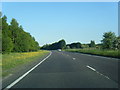
2
Alloa Road
Former main road, now replaced by a bypass, leaving Clackmannan towards Fife.
Image: © Richard Webb
Taken: 15 Oct 2009
0.12 miles
3
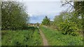
Path, Clackmannan
On the edge of Clackmannan, it links up with paths in a strip wood which runs up to Kennet.
Image: © Richard Webb
Taken: 20 May 2015
0.22 miles
4
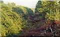
Trackbed of Alloa - Culross - Dunfermline ex-NB line at site of Clackmannan station, 1991
View SE, towards Kincardine, Culross and Dunfermline. The station and passenger service ceased from 7/7/30, but they were open for goods until 28/12/64. In recent years (2008), however, the line has been reopened from Stirling and Alloa to allow coal to be brought from Hunterston to Longannet Power Station at Kincardine - cf. Richard Webb Image
Image: © Ben Brooksbank
Taken: 3 Sep 1991
0.25 miles