IMAGES TAKEN NEAR TO
CLACKMANNAN, FK10 4DH
Introduction
This page details the photographs taken nearby to FK10 4DH by members of the Geograph project.
The Geograph project started in 2005 with the aim of publishing, organising and preserving representative images for every square kilometre of Great Britain, Ireland and the Isle of Man.

There are currently over 7.5m images from over14,400 individuals and you can help contribute to the project by visiting https://www.geograph.org.uk
Image Map
Images are licensed for reuse under creativecommons.org/licenses/by-sa/2.0
Notes
- Clicking on the map will re-center to the selected point.
- The higher the marker number, the further away the image location is from the centre of the postcode.
Image Listing (7 Images Found)
Images are licensed for reuse under creativecommons.org/licenses/by-sa/2.0
Image
Details
Distance
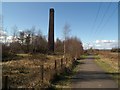
1
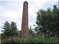
Cherryton Brickworks Chimney
This prominent landmark is beside the Dunfermline to Alloa cycleway near Tullygarth. The brickworks have been disused since the 1950s
Image: © Ian Mitchell
Taken: 24 Jul 2005
0.18 miles
2
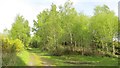
Cherryton Brickworks site
Looking away from the base of the chimney. As so often with industrial sites, the birches are well established.
Image: © Richard Webb
Taken: 20 May 2015
0.18 miles
3
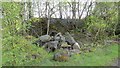
Cherryton Brickworks site
Remains of the brickworks now under woodland.
Image: © Richard Webb
Taken: 20 May 2015
0.18 miles
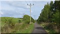
4
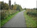
Stirling and Dunfermline Railway
The trackbed by the foot of the Cherryton brickworks chimney. This line was still shown as a railway on the 1976 Ordnance Survey 1:50,000 map and served collieries in the West Fife coalfield. Passenger services would have been withdrawn a lot earlier. Now it is a cycle/foot path operated by Clackmannanshire Council and Fife Council.
Image: © Richard Webb
Taken: 15 Oct 2009
0.19 miles
5
Cherryton brickworks
Although Cherryton brickworks ceased operations in the 1950s, its chimney still remains today.
Image: © Euan Nelson
Taken: 18 Mar 2012
0.19 miles
6
Stirling and Dunfermline Railway
The railway was shown as operational on the first 1:50,000 map published in 1976. Now it is a well surfaced cycle path.
Image: © Richard Webb
Taken: 20 May 2015
0.20 miles
7
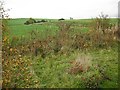
Farmland opposite Cherryton brickworks
View from the railway trackbed/cyclepath of grassland.
Image: © Richard Webb
Taken: 15 Oct 2009
0.22 miles