IMAGES TAKEN NEAR TO
Clackmannan Road, ALLOA, FK10 4DA
Introduction
This page details the photographs taken nearby to Clackmannan Road, FK10 4DA by members of the Geograph project.
The Geograph project started in 2005 with the aim of publishing, organising and preserving representative images for every square kilometre of Great Britain, Ireland and the Isle of Man.

There are currently over 7.5m images from over14,400 individuals and you can help contribute to the project by visiting https://www.geograph.org.uk
Image Map
Images are licensed for reuse under creativecommons.org/licenses/by-sa/2.0
Notes
- Clicking on the map will re-center to the selected point.
- The higher the marker number, the further away the image location is from the centre of the postcode.
Image Listing (25 Images Found)
Images are licensed for reuse under creativecommons.org/licenses/by-sa/2.0
Image
Details
Distance
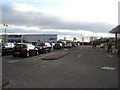
5
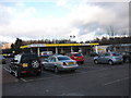
Car park and petrol station at Morrisons in Alloa
Image: © James Denham
Taken: 31 Jan 2010
0.08 miles
6
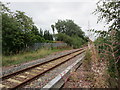
The railway to Kincardine and Dunfermline
This section of line went out of use in 1979 but was rebuilt in 2008 to allow coal imported through Hunterston to access Longannet power station without using the Forth Rail Bridge at Queensferry. Since the closure of Longannet powerstation in 2016 the line has seen only occasional use. Hopes of resurrecting a passenger service have not, as yet, been developed into firm proposals.
Image: © Jonathan Thacker
Taken: 17 Aug 2018
0.11 miles
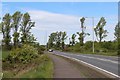
7

These crossing barriers will never rise again
The dashed white line heading straight into a high metal palisade fence is an indication that until a few months before the photograph was taken this part of Hilton Road led straight through to the main road east out of Alloa towards Fife; indeed, the road direction sign is still in position at the junction in the distance. Part of the costs quoted for the re-opening of the Alloa to Kincardine railway for coal trains to Longannet power station was for a new road crossing the railway on a bridge about half a mile to the east. This allowed the former level crossing in Hilton Road to be closed to vehicles. It had been the intention to provide a footbridge across the railway here for pedestrians but local residents said they didn't want one, preferring to use their cars to drive the long way round to the main road.
Image: © A-M-Jervis
Taken: 16 Apr 2008
0.12 miles
9
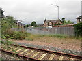
Railway and Hilton Road
There used to be a level crossing here and Hilton Road was the B909, but a bypass has been built and the crossing has been abolished (even for pedestrians).
Image: © Jonathan Thacker
Taken: 17 Aug 2018
0.14 miles
10
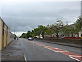
Looking east-southeast along Clackmannan Road
Image: © Basher Eyre
Taken: 12 Aug 2014
0.15 miles