IMAGES TAKEN NEAR TO
Kincardine, ALLOA, FK10 4AS
Introduction
This page details the photographs taken nearby to FK10 4AS by members of the Geograph project.
The Geograph project started in 2005 with the aim of publishing, organising and preserving representative images for every square kilometre of Great Britain, Ireland and the Isle of Man.

There are currently over 7.5m images from over14,400 individuals and you can help contribute to the project by visiting https://www.geograph.org.uk
Image Map
Images are licensed for reuse under creativecommons.org/licenses/by-sa/2.0
Notes
- Clicking on the map will re-center to the selected point.
- The higher the marker number, the further away the image location is from the centre of the postcode.
Image Listing (5 Images Found)
Images are licensed for reuse under creativecommons.org/licenses/by-sa/2.0
Image
Details
Distance
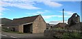
2
Bordie
Looking west to Bordie, the road on the right of the picture is the A985[T] from Rosyth to Kincardine.
Image: © Paul McIlroy
Taken: 8 Aug 2006
0.11 miles
3
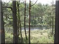
Lochan, Bordie Moor
A lochan in Devilla Forest, viewed from a newly upgraded path.
Image: © Richard Webb
Taken: 14 Jun 2009
0.23 miles
4
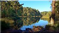
Bordie Loch on a still morning
In the Devilla Forest.
Image: © Gordon Brown
Taken: 28 Sep 2019
0.23 miles
5
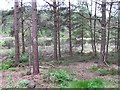
Lochan, Devilla Forest
A shallow lochan in the hummocky terrain of Culross Moor.
Image: © Richard Webb
Taken: 1 Jun 2011
0.24 miles