IMAGES TAKEN NEAR TO
The Whins, ALLOA, FK10 3SA
Introduction
This page details the photographs taken nearby to The Whins, FK10 3SA by members of the Geograph project.
The Geograph project started in 2005 with the aim of publishing, organising and preserving representative images for every square kilometre of Great Britain, Ireland and the Isle of Man.

There are currently over 7.5m images from over14,400 individuals and you can help contribute to the project by visiting https://www.geograph.org.uk
Image Map
Images are licensed for reuse under creativecommons.org/licenses/by-sa/2.0
Notes
- Clicking on the map will re-center to the selected point.
- The higher the marker number, the further away the image location is from the centre of the postcode.
Image Listing (6 Images Found)
Images are licensed for reuse under creativecommons.org/licenses/by-sa/2.0
Image
Details
Distance
4
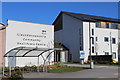
Clackmannanshire Community Healthcare Centre, Sauchie
Image: © Leslie Barrie
Taken: 18 Apr 2014
0.21 miles
5
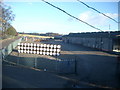
Carsebridge, Alloa
Showing whisky maturation warehouses (at the back) and cooperage stores plus including some shooks and hoop iron waiting to go into the copperage on the other side of the road on the left.
Image: © Kirsty Smith
Taken: 16 Nov 2005
0.23 miles
6
Red bridge and blue cars at Alloa
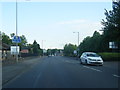
A new high-security fence blocks the end of Bruce Street to prevent trespassers being run down by coal trains when the line from Stirling through Alloa to Kincardine and Longannet power station is re-opened later in the year. A refurbished metal footbridge continues to connect the road with the housing scheme to the north; it had fallen out of use during the twenty years or so that the railway line was disused, passing pedestrians having broken down the original wire fences to cross the rails on the level.
Image: © A-M-Jervis
Taken: 16 Apr 2008
0.23 miles