IMAGES TAKEN NEAR TO
ALLOA, FK10 3PZ
Introduction
This page details the photographs taken nearby to FK10 3PZ by members of the Geograph project.
The Geograph project started in 2005 with the aim of publishing, organising and preserving representative images for every square kilometre of Great Britain, Ireland and the Isle of Man.

There are currently over 7.5m images from over14,400 individuals and you can help contribute to the project by visiting https://www.geograph.org.uk
Image Map
Images are licensed for reuse under creativecommons.org/licenses/by-sa/2.0
Notes
- Clicking on the map will re-center to the selected point.
- The higher the marker number, the further away the image location is from the centre of the postcode.
Image Listing (5 Images Found)
Images are licensed for reuse under creativecommons.org/licenses/by-sa/2.0
Image
Details
Distance
1
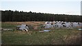
The Forest
Gartlove Plantation in the big wood known simply as The Forest.
Image: © Richard Webb
Taken: 4 Jun 2006
0.13 miles
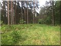
2
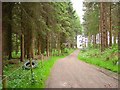
Gartlove Plantation
Track towards some open land.
Image: © Richard Webb
Taken: 4 Jun 2006
0.13 miles
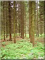
3
Birkhill Plantation
The oak wood in the foreground is damp underfoot, the better drained slopes ahead are planted with Scots pine.
Image: © Richard Webb
Taken: 28 May 2019
0.14 miles
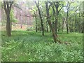
4
Birkhill Plantation
Scots pine woodland.
Image: © Richard Webb
Taken: 28 May 2019
0.19 miles