IMAGES TAKEN NEAR TO
The Laurels, ALLOA, FK10 2XE
Introduction
This page details the photographs taken nearby to The Laurels, FK10 2XE by members of the Geograph project.
The Geograph project started in 2005 with the aim of publishing, organising and preserving representative images for every square kilometre of Great Britain, Ireland and the Isle of Man.

There are currently over 7.5m images from over14,400 individuals and you can help contribute to the project by visiting https://www.geograph.org.uk
Image Map
Images are licensed for reuse under creativecommons.org/licenses/by-sa/2.0
Notes
- Clicking on the map will re-center to the selected point.
- The higher the marker number, the further away the image location is from the centre of the postcode.
Image Listing (9 Images Found)
Images are licensed for reuse under creativecommons.org/licenses/by-sa/2.0
Image
Details
Distance
1
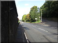
Road (A907) being joined by a road from Tullibody
Looking north-westward.
Image: © Peter Wood
Taken: 30 Sep 2017
0.13 miles
2

Ordnance Survey Flush Bracket G685
This bracket can be found on the wall of a building beside the A907 road between Cambus and Tullibody/ The benchmark height is recorded as being 10.412 metres above sea level. For more detail see : http://www.bench-marks.org.uk/bm17848
Image: © Peter Wood
Taken: 30 Sep 2017
0.15 miles
3
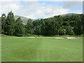
Braehead Golf Club, 2nd Hole, Cochrie
The second hole at Braehead, looking to the green, with the Ochil Hills visible above the trees.
Image: © Scott Cormie
Taken: 29 Jun 2023
0.19 miles
5
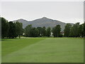
Braehead Golf Club, 17th Hole, Abercromby
The seventeenth hole at Braehead, looking to the green, with Dumyat in the background.
Image: © Scott Cormie
Taken: 29 Jun 2023
0.20 miles
6
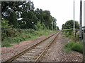
The railway to Alloa
Electrification masts have been installed but the overhead is not yet fitted.
Image: © Jonathan Thacker
Taken: 17 Aug 2018
0.22 miles
7

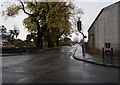
Network Rail should practice using Geograph!
No, this photograph of a sign on Cambus Level Crossing, between Stirling and Alloa, has not been placed in the wrong Geograph square! It is the sign that is wrong; the second and third digits have been transposed. One hopes that the emergency services never have to be called out for an incident here, as if they go to the given grid reference they will end up in the middle of a golf course a kilometre away.
Image: © A-M-Jervis
Taken: 16 Apr 2008
0.23 miles
8

Braehead Golf Club, 1st Hole, Newbiggin
The opening hole at Braehead, looking to the green over a gully.
Image: © Scott Cormie
Taken: 29 Jun 2023
0.23 miles
9
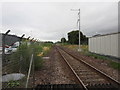
The railway to Stirling
Electrification masts installed but not yet the overhead.
Image: © Jonathan Thacker
Taken: 17 Aug 2018
0.25 miles