IMAGES TAKEN NEAR TO
Newlands Place, ALLOA, FK10 2SN
Introduction
This page details the photographs taken nearby to Newlands Place, FK10 2SN by members of the Geograph project.
The Geograph project started in 2005 with the aim of publishing, organising and preserving representative images for every square kilometre of Great Britain, Ireland and the Isle of Man.

There are currently over 7.5m images from over14,400 individuals and you can help contribute to the project by visiting https://www.geograph.org.uk
Image Map
Images are licensed for reuse under creativecommons.org/licenses/by-sa/2.0
Notes
- Clicking on the map will re-center to the selected point.
- The higher the marker number, the further away the image location is from the centre of the postcode.
Image Listing (10 Images Found)
Images are licensed for reuse under creativecommons.org/licenses/by-sa/2.0
Image
Details
Distance
1
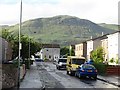
Banchory Place, Tullibody
Residential street off Alloa Road. View towards Craig Leith on the Ochil scarp.
Image: © Richard Webb
Taken: 18 May 2011
0.05 miles
2
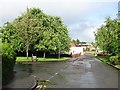
Alloa Road, Tullibody
Service road running parallel with the B9096. The trees are on the junction with Banchory Place.
Image: © Richard Webb
Taken: 18 May 2011
0.08 miles
3
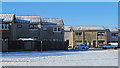
Snow on roads and rooftops, Tullibody
Snowfall on the rooftops of Tullibody, viewed in March 2013. After a period of mild weather, wintry conditions have returned to central Scotland, creating difficult driving conditions.
Image: © William Starkey
Taken: 11 Mar 2013
0.14 miles
4
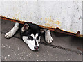
Let me out
A forlorn looking hound peering under an iron gate in Tullibody.
Image: © William Starkey
Taken: 3 Mar 2011
0.14 miles
5
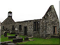
Old Kirk, Tullibody
The Old Kirk in Tullibody, originally constructed in the 12th century, and rebuilt in the 16th and 17th centuries. In 1560, William Kirkcaldy of Grange broke down the bridge over the River Devon at Tullibody to impede the retreat of a french army. Undaunted, the french used the rafters of the Kirk at Tullibody to repair the bridge.
Image: © William Starkey
Taken: 3 Mar 2011
0.15 miles
6
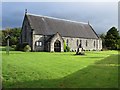
St Serf's Church at Tullibody
Viewed from the south-west.
Image: © Peter Wood
Taken: 30 Sep 2017
0.15 miles
7
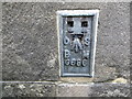
Ordnance Survey Flush Bracket G686
This bracket can be found on the wall of St Serf's Church at Tullibody. The benchmark height is recorded as being 32.674 metres above sea level. For more detail see : http://www.bench-marks.org.uk/bm345
Image: © Peter Wood
Taken: 30 Sep 2017
0.16 miles
8
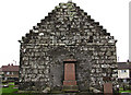
Old Kirk, Tullibody
The east facing wall of the Old Kirk at Tullibody
Image: © William Starkey
Taken: 3 Mar 2011
0.17 miles
9
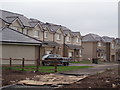
Muirside
New housing development to the north of Tullibody
Image: © Angela Mudge
Taken: 12 Jul 2006
0.19 miles
10
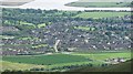
Tullibody
View of Tullibody and the Forth from Colsnaur Hill.
Image: © Richard Webb
Taken: 14 May 2011
0.23 miles